NASA's Aqua satellite orbit around the Earth took it right over Typhoon Pabuk and the image showed an eye veiled with some high clouds.
The Moderate Resolution Imaging Spectroradiometer or MODIS instrument that flies aboard NASA's Aqua satellite captured a visible image of Typhoon Pabuk on Sept. 24 at 04:05 UTC as it was nearing Japan. In the image, high clouds draped over Pabuk's eye. Pabuk's eye is about 30 nautical miles/34.5 miles/55.5 km wide, about three times larger than Typhoon Usagi's eye before it made landfall in China earlier in the week.
On Tuesday, Sept. 24 at 0900 UTC/5 a.m. EDT, Pabuk's maximum sustained winds were near 65 knots/75 mph/120.4 kph and some slight strengthening is expected. Pabuk's center was located near 26.4 north and 139.2 east, about 552 nautical miles/ 635.2 miles/1,022 km south of Yokosuka, Japan. Pabuk is currently moving to the northwest, but is expected to turn to the northeast.
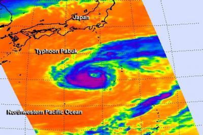
On Sept. 24 at 03:59 UTC the AIRS instrument aboard NASA's Aqua satellite captured this infrared image of Typhoon Pabuk's visible eye and very cold (purple) cloud tops and powerful thunderstorms.
(Photo Credit: Image : NASA JPL, Ed Olsen)
The Joint Typhoon Warning Center forecast expects Pabuk to track parallel to the coast of Japan while now staying away from the big island. Pabuk is expected to become an extra-tropical cyclone in the next couple of days and gain frontal characteristics.
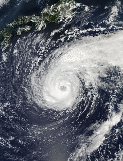
The MODIS instrument aboard NASA's Aqua satellite captured this image of Typhoon Pabuk on Sept. 24 at 04:05 UTC as it was nearing Japan. High clouds drape over Pabuk's eye.
(Photo Credit: Image : NASA Goddard MODIS Rapid Response Team)
Source: NASA/Goddard Space Flight Center