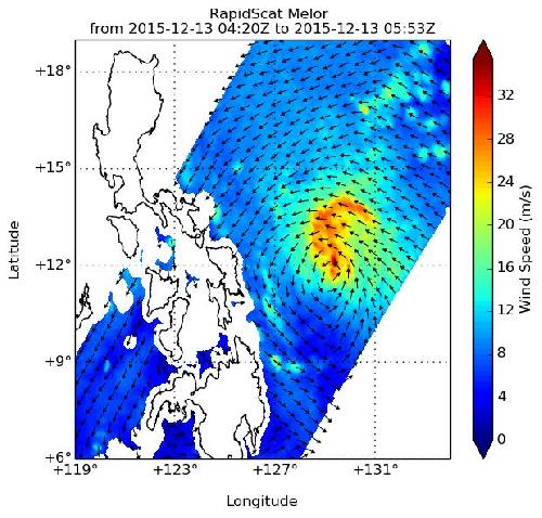
As Typhoon Melor approached a landfall in the central Philippines, NASA's RapidScat instrument identified the strongest winds north of the center. As the storm was making landfall in the eastern Visayas and Bicol regions of the Philippines early on Dec. 14, 2015 NASA-NOAA's Suomi NPP satellite provided a visible image that showed the extend of the storm.
On Dec. 13, 2015 NASA's RapidScat instrument measured winds in Typhoon Melor and saw the strongest sustained winds near 36 meters per second/80.5 mph/129.6 kph north of the center. Maximum sustained winds are not always equally distributed in a hurricane or tropical storm, and the RapidScat instrument helps forecasters find the strongest quadrants of a storm. RapidScat is an instrument that flies aboard the International Space Station.
The Visible Infrared Imaging Radiometer Suite (VIIRS) instrument aboard NASA-NOAA's Suomi NPP satellite captured a visible image of Melor on Dec. 14, 2015 at 05:43 UTC (12:43 a.m. EST) as it was making landfall in eastern Visayas, Philippines. At the time of the image, there was no visible eye, despite being at typhoon intensity. Bands of thunderstorms spiraling into the center from the southwest stretched over the eastern Visayas regions.
 On Dec. 13, 2015, NASA's RapidScat instrument measured winds in Typhoon Melor and saw the strongest sustained winds near 36 meters per second//80.5 mph/129.6 kph north of the center. Credit: Credits: NASA JPL, Doug Tyler
The Joint Typhoon Warning Center (JTWC) noted "animated enhanced infrared satellite imagery shows the system has significantly degraded as it dragged across the Philippine archipelago."
At 1500 UTC (10 a.m. EST) on Dec. 14, 2015 many signals were in effect throughout the Philippines as Melor continued to move through the islands. Public storm warning signal #3 was in effect in the following provinces: Luzon: Sorsogon, Masbate including Ticao and Burias Islands, Albay, Camarines Sur & Norte, Catanduanes, Southern Quezon, Marinduque and Romblon. In Visayas: Northern Samar. Public storm warning signal #2 was in effect in the following provinces: Luzon: Batangas, Rizal, Laguna, Cavite, rest of Quezon including Polillo Island, Oriental and Occidental Mindoro including Lubang Island. In Visayas: Eastern Samar, Samar and Biliran. Public storm warning signal #1 was in effect in the following provinces: Luzon: Metro Manila, Bulacan, Bataan, Pampanga, Southern Zambales, Southern Aurora and Coron.
In Visayas: Leyte, Northern Cebu including Bantayan and Camotes Islands, Aklan, Capiz, Northern Antique, Northern Negros Occidental and Northern Iloilo.
At that time, Melor, known locally as Nona in the Philippines, was centered about 177 nautical miles southeast of Manila, near 12.8 degrees north latitude and 123.4 degrees east longitude. Melor's maximum sustained winds were near 90 knots (103.6 mph/166.7 kph). Melor was moving to the west at 11 knots (12.6 mph/20.3 kph) and is expected to curve to the west-northwest as it continues to head to the South China Sea.
Melor is passing through the islands of the Philippines and weakening. JTWC expects the storm to move over the Mimaropa region. Melor's winds are forecast to decrease to tropical storm force (near 55 knots/63.2 mph/101.9 kph) by Dec. 15, 2015 at 1200 UTC (7 a.m. EST). By Dec. 16, 2015 Melor is expected to weaken into a remnant low pressure area over South China Sea.
JTWC noted that land interaction, increasing vertical wind shear and the intrusion of cold dry air associated with a strong continental cold surge in the South China Sea are the reasons why Melor is expected to dissipate by Dec. 17, 2015.
source: NASA/Goddard Space Flight Center