NASA's TRMM satellite observed Typhoon Lekima's shrinking eye on Oct. 24, and by the Oct. 25, the eye had shrunk to just 4 nautical miles. TRMM also observed very heavy rainfall occurring around the eyewall of the storm.
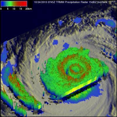
NASA's TRMM satellite flew above the center of Super-typhoon Lekima in the western North Pacific Ocean early on Oct. 24 and data was used to create a 3-D image of the storm's structure. TRMM's first orbit provided a look at Super-typhoon Lekima at 0745 UTC/3:45 a.m. EDT. Lekima was somewhat close to Tropical Storm Francisco. Lekima was located southeast of Tropical Storm Francisco over the open waters of the Pacific.
At NASA's Goddard Space Flight Center in Greenbelt, Md. the data TRMM gathered was used to create imagery of the storm. Precipitation data from TRMM's Microwave Imager (TMI) and Precipitation Radar (PR) instruments were overlaid on infrared images from TRMM's Visible and InfraRed Scanner (VIRS).
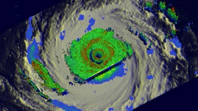
TRMM's PR data revealed that Lekima had a small well defined eye at the center of the super typhoon with another concentric outer replacement eye wall. Rain was falling at a rate of over 130mm/~5.2 inches per hour in the powerful storms in Lekima's outer eyewall. Lekima was the fourth super typhoon in the western Pacific this year with wind speeds estimated to be over 130 knots/~150 mph.
Radar reflectivity data from TRMM's PR instrument were used to create 3-D images that showed differences between super typhoon Lekima and tropical storm Francisco. TRMM is managed by both NASA and the Japan Aerospace Exploration Agency.
On Oct. 25, increasing wind shear is taking a toll on Typhoon Lekima, stretching it out and weakening convection in the storm. Enhanced infrared satellite imagery showed that Lekima's eye shrunk to a small pinhole, just 4 nautical miles/4.6 miles/7.4 km wide.
At 1500 UTC/11 a.m. on Oct. 25, Lekima's maximum sustained winds were near 100 knots/115 mph/185 kph. The eye of the storm was located near 30.7 north and 146.0 east, about 444 nautical miles southeast of Yokosuka, Japan. Lekima was moving speedily at 24 knots/27.6 mph/44.4 kph to the north-northeast and is expect to turn toward the east-northeast over the next couple of days, remaining far to the east of the big island of Japan.

This 3-D image of Super-Typhoon Lekima on Oct. 24, 2013 shows the heaviest rainfall rates and highest clouds in red.
(Photo Credit: : NASA/SSAI, Hal Pierce)

This is a TRMM 3-D flyby animation over Super-typhoon Lekima on Oct. 24 that shows cloud heights and rainfall.
(Photo Credit: : NASA/SSAI, Hal Pierce)
Source: NASA/Goddard Space Flight Center