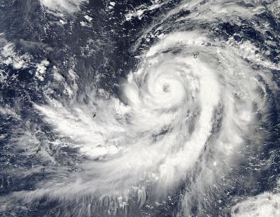
NASA's Aqua satellite passed over Typhoon Francisco on Oct. 17 after it had passed the eastern side of Guam and started to head on a track that would take it past the western side of Guam. Tropical Storm Warnings are in effect for Guam on Oct. 17 and 18 (local time).
The Moderate Resolution Imaging Spectroradiometer instrument aboard NASA's Aqua satellite captured an image of Typhoon Francisco on Oct. 17 at 04:05 UTC in the Pacific Ocean as it started turning to the northwest after passing the eastern side Guam. The MODIS image clearly showed Francisco's eye, indicating its strength and organization.
On Oct. 17 at 1500 UTC/11 a.m. EDT Francisco had maximum sustained winds near 85 knots and was moving to the north-northeast, but is expected to take a turn to the northwest. Francisco's center was located about 147 nautical miles southwest of Guam, near 12.5 north and 143.1 east.

NASA's Aqua satellite captured this image of Typhoon Francisco on Oct. 17 at 04:05 UTC in the Pacific Ocean as it started turning to the northwest after passing Guam.
(Photo Credit: Image : NASA Goddard MODIS Rapid Response Team)
On Oct. 17 and 18 (local time), a Tropical Storm Warning was in effect for Guam. The National Weather Service bulletin on Oct. 17 at 3 p.m. EDT noted: as Typhoon Francisco (26w) passes...sustained tropical storm force winds are expected. Maximum winds are still forecast to be in the 30 to 40 mph range with gusts to 60 mph. Minor damage may occur to poorly constructed homes. Isolated power outages will be possible. Choppy seas of 12 to 14 feet will persist through tonight.
Source: NASA/Goddard Space Flight Center