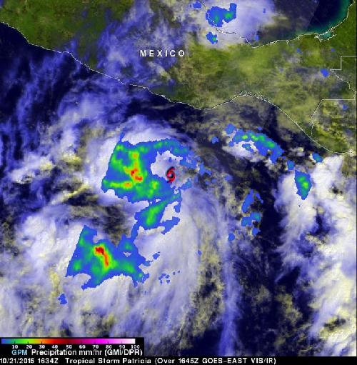
NASA's GPM satellite saw that the western side of Tropical Storm Patricia was packing most of the storm's moderate and heavy rainfall when it passed overhead in space. Patricia was close to the coast of western Mexico, and triggered warnings and watches. Patricia intensified into a hurricane on Oct. 22.
Tropical Depression Twenty-E (TD20E) formed on Oct. 20, 2015 off the Mexican coast southeast of Puerto Escondido, Mexico. Later that evening TD20E was upgraded to tropical Storm Patricia.
GPM Sees Lopsided Rainfall
 NASA's GPM satellite saw that the western side of Tropical Storm Patricia was packing most of the storm's moderate and heavy rainfall when it passed overhead in space. Patricia was close to the coast of western Mexico, and triggered warnings and watches. Credit: Credits: NASA/SSAI/JAXA, Hal Pierce
On Oct. 21, 2015 at 1634 UTC (11:34 a.m. CDT) the GPM or Global Precipitation Measurement mission core observatory satellite flew over tropical storm Patricia. GPM is co-managed by NASA and the Japan Aerospace Exploration Agency and can measure rainfall rates from space.
GPM's Microwave Imager (GMI) instrument had good coverage of the rainfall associated with the tropical storm. At NASA's Goddard Space Flight Center in Greenbelt, Maryland, a complete picture of the storm came together that included rainfall and clouds. Rainfall data derived from GMI were overlaid on a visible/infrared image from NOAA's GOES-West satellite that was captured at 1645 UTC (11:45 a.m. CDT). GPM's Dual-Frequency Precipitation Radar (DPR) instrument scanned along an area east of Patricia's center of circulation. Rain was measured by GMI falling at a rate of over 55 mm (2.16 inches) per hour in storms west of Patricia's center.
Heavy Rains for Four Mexican States Expected on Oct. 22
The heavy rains seen in the GPM imagery are expected to affect southwestern Mexico on Oct. 22. The National Hurricane Center noted that Patricia is expected to produce total rainfall accumulations of 6 to 12 inches, with isolated maximum amounts of 20 inches, over the Mexican states of Jalisco, Colima, Michoacan and Guerrero later today, Oct. 22, into Saturday, Oct. 24.
Warnings and Watches on Oct. 22
On Oct. 22, 2015, Patricia had become a hurricane and at 8 a.m. EDT, the National Hurricane Center noted that the storm was intensifying quickly. Several warnings and watches were in effect. A Hurricane Warning is in effect from Cabo Corrientes to Punta San Telmo, and a Hurricane Watch is in effect from the east of Punta San Telmo to Lazaro Cardenas.
A Tropical Storm Warning is in effect from east of Punta San Telmo to Lazaro Cardenas, and a Tropical Storm Watch is in effect from east of Lazaro Cardenas to Tecpan De Galeana.
Patricia's Stats on Oct. 22, 2015
The National Hurricane Center (NHC) reported that at 8 a.m. EDT (1200 UTC) on Oct. 22, the center of Hurricane Patricia was located near latitude 14.7 degrees north and longitude 103.0 degrees west. That put the center about 235 miles (375 km) south-southwest of Lazaro Cardenas, Mexico, and about 310 miles (500 km) south-southeast of Manzanillo, Mexico.
Patricia was moving toward the west-northwest near 17 mph (28 kph), and a turn toward the northwest is expected later today or tonight, followed by a turn toward the north on Friday. NHC said "On the forecast track, the center of the hurricane will be crossing the coast of Mexico in the hurricane warning area by Friday evening, Oct. 23."
Maximum sustained winds have increased to near 90 mph (150 kph) with higher gusts. Hurricane force winds extend outward up to 25 miles (35 km) from the center and tropical storm force winds extend outward up to 115 miles (185 km). The estimated minimum central pressure is 973 millibars. Continued strengthening is forecast, and Patricia is likely to become a major hurricane later today or tonight. Thereafter, additional strengthening is forecast until landfall.
NHC noted that a dangerous storm surge is expected to produce significant coastal flooding near and to the right of where the center makes landfall. Near the coast, the surge will be accompanied by large and destructive waves. Swells generated by Patricia are affecting portions of the coast of southern Mexico. These swells are likely to cause life-threatening surf and rip current conditions.
source: NASA/Goddard Space Flight Center