Tropical Storm Haikui is headed for landfall in southeastern China, and NASA's Aqua satellite caught a stunning image of its size and its ragged, but wide eye when it was a typhoon earlier today, August 7. As a result of interaction with land, Haikui has weakened to a tropical storm.
When NASA's Aqua satellite passed over Typhoon Haikui on August 6, 2012 at 12:35 a.m. EDT the Moderate Resolution Imaging Spectroradiometer (MODIS) instrument onboard captured an image of the storm as it was approaching China. The MODIS image clearly showed Haikui's ragged and elongated eye and the northwestern edge of the storm was already over southeastern China at that time.
By August 7 at 1500 UTC (11 a.m. EDT), Haikui dropped down to tropical storm status with maximum sustained winds near 60 knots (69 mph/111 kmh) as it approached the China coastline. Tropical-storm-force winds extend out as far as 100 nautical miles (115 miles/185 km) from the center. Haikui was located approximately 225 nautical miles (259 miles/416.7 km) south-southeast of Shanghai, China, near 28.4 North latitude and 122.5 East longitude. It was headed northwest at 8 knots. Because Haikui was generating 28-foot-high (8.5 meter) seas, residents along the coast can expect dangerous surf, flooding, and coastal erosion.
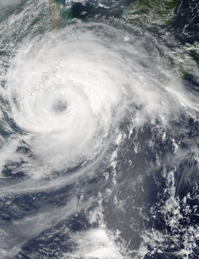
When NASA's Aqua satellite passed over Typhoon Haikui on Aug. 6, 2012 at 0435 UTC (12:35 a.m. EDT) the MODIS instrument onboard captured this image of the storm as it was approaching China.
(Photo Credit: : NASA Goddard MODIS Rapid Response Team)
The Joint Typhoon Warning Center forecasts Typhoon Haikui to maintain its current track and make landfall south of Zhoushan, China by 10 p.m. EDT/U.S. today, August 7 and then turn to the northeast.
Source: NASA/Goddard Space Flight Center