NASA's Terra satellite captured an image of Tropical Storm Fengshen as it continued moving away from the east coast of Japan. Satellite imagery showed that the storm resembled a frontal system more than a tropical storm because it appeared stretched from southwest to northeast
NASA's Terra satellite flew over Tropical Storm Fengshen on Sept. 9 at 1:05 UTC (Sept. 8 at 9:05 p.m. EDT) and the Moderate Resolution Imaging Spectroradiometer or MODIS instrument captured an image of the massive storm. The MODIS image showed that the bulk of Fenghsen's clouds were north and northeast of the center as the storm began its transition into an extra-tropical storm.
On September 9 at 1500 UTC (11 a.m. EDT), Fengshen's exposed and elongated center of circulation was located near 34.3 north and 148.3 east. It was about 370 nautical miles (425.8 miles/685 km) east of Yokosuka, Japan and moving to the east-northeast at 18 knots (20.7 mph/33.3 kph). Maximum sustained winds were near 50 knots 57.5 mph/92.6 kph).
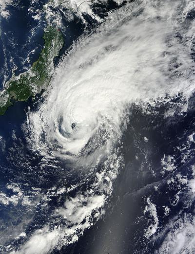
NASA's Terra satellite captured this image of Tropical Storm Fengshen off Japan's east coast on Sept. 9 at 1:05 UTC.
(Photo Credit: NASA Goddard MODIS Rapid Response Team)
The Joint Typhoon Warning Center forecast takes Fengshen on a more east-northeasterly track over the open waters of the Northwestern Pacific Ocean over the next several days as it continues to stretch out and transition from a warm core tropical storm to a cold core, extra-tropical storm. The Joint Typhoon Warning Center has issued its final bulletin on Fengshen as it spins over open waters and into hurricane history.
Source: NASA/Goddard Space Flight Center