Tropical Depression 08W strengthened into a tropical storm and was renamed Cimaron by the morning of July 17. NASA's Aqua satellite captured the storm is it passed between the northern Philippines and Taiwan.
On July 17 at 0900 UTC, Tropical Storm Cimaron was located about 294 nautical miles (338.3 miles/544.5 km) north of Manila, Philippines, near 19.9 north latitude and 120.8 east longitude. Cimaron's maximum sustained winds increased to 35 knots (40 mph/64 kph) and the tropical storm is moving to the northwest at 18 knots (20.7 mph/33.3 kph). Cimaron is generating 14 foot-high (4.2 meter-high) waves in the South China Sea between southern Taiwan and the northern Philippines.
Forecasters at the Joint Typhoon Warning Center expect Cimaron to continue tracking to the northwest and make landfall in southeastern China on July 18.
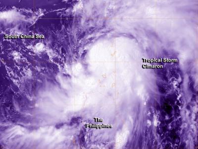
The MODIS instrument aboard NASA's Aqua satellite captured this visible (color-enhanced) image of Tropical Storm Cimaron passing between Taiwan and the Philippines on July 17 at 0522 UTC (1:22 a.m. EDT).
(Photo Credit: Image : NASA/NRL)
Animated multispectral satellite imagery indicated that the banding of thunderstorms around the center have been improving and have been wrapping more tightly into the center in the morning hours of July 17. The center is becoming more organized, as is evident in visible imagery taken from the Moderate Resolution Imaging Spectroradiometer (MODIS) instrument that flies aboard NASA's Aqua satellite. MODIS captured a visible image of Tropical Storm Cimaron passing between Taiwan and the Philippines on July 17 at 0522 UTC (1:22 a.m. EDT).
The Atmospheric Infrared Sounder or AIRS instrument that flies aboard AIRS showed the southern quadrant of Cimaron skirting northern Luzon. The strongest thunderstorms, however, remained over the South China Sea.
Cimaron quickly tracked across the northeastern tip of Luzon, Philippines early on July 17 and is forecast to make landfall in eastern China approximately 200 nautical miles (230 miles/370 km) northeast of Hong Kong.
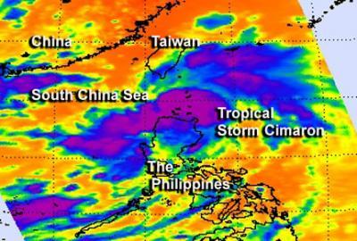
The AIRS instrument aboard NASA's Aqua satellite captured this infrared image of Tropical Storm Cimaron passing between Taiwan and the Philippines on July 17 at 0517 UTC (1:17 a.m. EDT).
(Photo Credit: Image : NASA/NRL)
Source: NASA/Goddard Space Flight Center