The rainfall rate image was created at NASA's Goddard Space Flight Center in Greenbelt, Md. by adding together data from two TRMM instruments. The rain rates in the center of the swath are from the TRMM Precipitation Radar (PR), and those in the outer swath are from the TRMM Microwave Imager (TMI). The rain rates are overlaid on infrared (IR) data from the TRMM Visible Infrared Scanner (VIRS).
The TRMM image showed most of the rain was well ahead of the center of circulation. A broad area of light to moderate rain covered the eastern half of Georgia and all of South Carolina. A cluster of heavier rain cells was poised to move onshore along the upper part of the South Carolina coast while at the same time the area right around the storm's center was nearly devoid of rain. At the time of the image, Andrea had weakened slightly to a moderate tropical storm with sustained winds reported at 50 mph.
Andrea's Location
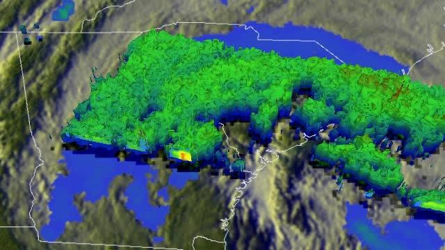
This flyby animation showed most of the rain was well ahead of the center of circulation. A broad area of light (shown in blue) to moderate rain (shown in green) covers the eastern half of Georgia and all of South Carolina. A cluster of heavier rain cells (shown in red) is poised to move onshore along the upper part of the South Carolina coast while at the same time the area right around the storm's center is nearly devoid of rain. At the time of this animation, Andrea had weakened slightly to a moderate tropical storm with sustained winds reported at 50 mph.
(Photo Credit: SSAI/NASA, Hal Pierce)
At 2 p.m. EDT on June 7, Andrea was losing its tropical characteristics, but some thunderstorms were still forming near the center. Andrea's maximum sustained winds were near 45 mph (75 kph), and it was moving to the northeast at 28 mph (44 kph). Andrea's minimum central pressure was near 996 millibars.
At that time, there was a tropical storm warning in effect from north of Little River Inlet to Cape Charles Light, Virginia and for the Pamlico and Ablemarle Sounds.
Coastal areas are dealing with the most threats and that will be the case as Andrea continues her northward track. For example, the following watches and hazards were in effect for coastal Maryland and Virginia for the lower Chesapeake Bay south of New Port Comfort: A Flood Watch until midnight, a Beach Hazards Statement, High Rip Current Risk and Tornado Watch until 8 p.m. EDT.
Rainfall continues to be a big threat from Andrea. The tropical storm is expected to produce total rain accumulations of 2 to 4 inches from central and eastern North Carolina northeastward along the eastern seaboard into coastal Maine. According to the National Hurricane Center, tropical storm conditions will continue to spread northeastward along the U.S. east coast strong winds are possible elsewhere along the coast from Virginia to Atlantic Canada through early Sunday, June 9. A few tornadoes are possible over eastern portions of North Carolina and Virginia today.
The National Hurricane Center expects Andrea to turn toward the east-northeast late on June 8.
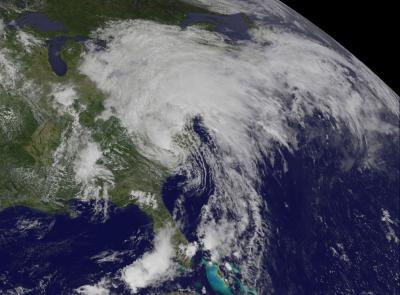
NOAA's GOES-14 satellite provided this visible image of Tropical Storm Andrea on Friday, June 7, at 2:31 p.m. EDT. The center of Andrea was near Fayetteville, North Carolina at the time, and the bulk of the clouds and rain stretched from northwest to northeast of the center. Andrea's clouds extended over the Great Lakes and New England.
(Photo Credit: NASA/NOAA GOES Project)
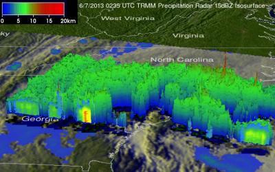
The TRMM image showed most of the rain was well ahead of the center of circulation. A broad area of light (shown in blue) to moderate rain (shown in green) covers the eastern half of Georgia and all of South Carolina. A cluster of heavier rain cells (shown in red) is poised to move onshore along the upper part of the South Carolina coast while at the same time the area right around the storm's center is nearly devoid of rain. At the time of this image, Andrea had weakened slightly to a moderate tropical storm with sustained winds reported at 50 mph.
(Photo Credit: SSAI/NASA, Hal Pierce)
Source: NASA/Goddard Space Flight Center