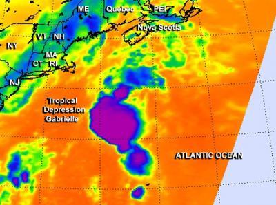
Eastern Canada is now expecting some winds and rain from Tropical Depression Gabrielle as it transfers its energy to a cold front. NASA's Aqua satellite captured an infrared image of Gabrielle that showed some very cold cloud top temperatures and strong thunderstorms around its center.
The Atmospheric Infrared Sounder instrument called AIRS that flies aboard NASA's Aqua satellite captured an infrared image of Tropical Depression Gabrielle on Sept. 13 at 06:29 UTC/2:29 a.m. EDT. The AIRS image showed a circular area of very high, cold cloud top temperatures surrounding its center. The cloud tops were as cold or colder than -63F/-52C, indicating they stretched high in the troposphere, and have the potential for dropping heavy rainfall.
On Sept. 13, the Canadian Hurricane Centre of Environment Canada issued a Tropical cyclone information statement for: Newfoundland, Nova Scotia and Prince Edward Island.

NASA's Aqua satellite captured an infrared image of Tropical Depression Gabrielle on Sept. 13 at 2:29 a.m. EDT that showed a circular area of very high, cold cloud top temperatures colder than -63F/-52C surrounding its center.
(Photo Credit: : NASA JPL/Ed Olsen)
At 11 a.m. EDT/1500 UTC, Tropical Depression Gabrielle had maximum sustained winds near 35 mph/ 55 kph. It was centered near latitude 39.1 north and longitude 66.5 west, about 245 miles/390 km southeast of Nantucket, Massachusetts and 410 miles/655 km south-southwest of Halifax, Nova Scotia. Gabrielle is moving to the north-northeast near 23 mph/37 kph and expected to continue moving north-northeast while speeding up later in the day on Sept. 13.
The National Hurricane Center expects Gabrielle's circulation to dissipate as it approaches Nova Scotia and merge with a cold front later on Sept. 13. The cold front is approaching from the west and Gabrielle's moisture is already being drawn into it, so heavy rainfall was affecting Nova Scotia during the morning hours of Sept. 13 and spreading to Prince Edward Island. For more details on the forecast for eastern Canada, visit: http://weather.gc.ca/hurricane/statements_e.html.
According to the Canadian Hurricane Centre, whatever remains of Gabrielle's wind will likely clip Eastern Nova Scotia during the night-time hours on Sept. 13.
Source: NASA/Goddard Space Flight Center