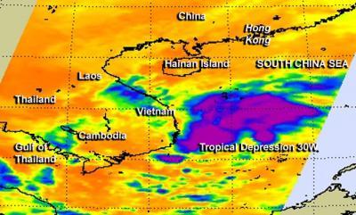
Tropical Storm 30W weakened into a tropical depression again on Nov. 6 and wind shear stretched out the storm. The storm's elongation was evident in infrared NASA satellite imagery.
NASA's Aqua satellite passed over Tropical Depression 30W on Nov. 5 at 18:23 UTC/1:23 p.m. EST. The Atmospheric Infrared Sounder or AIRS instrument captured infrared data about the storm's cloud top temperatures. The AIRS data also showed wind shear had stretched the system from west to east.
On Nov. 6 Tropical Depression 30W was making landfall in southern Vietnam. At 0900 UTC/4 a.m. EST, the final warning from the Joint Typhoon Warning Center placed the center of the depression about 200 nautical miles/230.2 miles/370.4 km east-northeast of Ho Chi Minh City, Vietnam, near 10.9 north and 115.3 east. It was moving to the west at 12 knots/13.8 mph/ 22.2 kph, and its maximum sustained winds had dropped to 25 knots/28.7 mph/ 46.3 kph.

NASA's Aqua satellite passed over Tropical Depression 30W on Nov. 5 at 1:23 p.m. EST and saw that wind shear had stretched the system and the strongest thunderstorms from west to east.
(Photo Credit: NASA JPL, Ed Olsen)
Animated multispectral satellite imagery showed that thunderstorm development was shallow as the storm continued to stretch out. Tropical Depression 30W is expected to dissipate over southern Vietnam in the next day, although the Joint Typhoon Warning Center noted that there is a chance of regeneration once the remnants move over the Gulf of Thailand or the Andaman Sea.
Source: NASA/Goddard Space Flight Center