Powerful Tropical Cyclone Hellen rapidly weakened after hitting northwestern Madagascar but Hellen's remnants have recently started to show signs of life. The TRMM satellite flew over these remnants in the Mozambique Channel on April 2, 2014 at 0143 UTC.
A rainfall analysis using the Tropical Rainfall Measuring Mission's (TRMM) Microwave Imager (TMI) and Precipitation Radar (PR) instruments found that some strong convective thunderstorms had developed in the area. It was revealed by TRMM PR data that rain was falling at a rate of over 75 mm/~ 3 inches in a few locations.
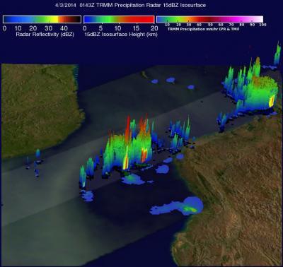
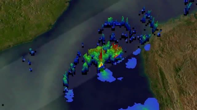
TRMM's Precipitation Radar (PR) data were used to create a 3-D image that showed the structure in the convective thunderstorms near the center of Hellen's remnants. The 3-D view showed that a few of these tall thunderstorms were reaching heights of over 16 km/9.9 miles.
At 1800 UTC/2:00 p.m. EDT on April 1, the center of Hellen's remnants were located near 18.3 south and 42.3 east, about 271 nautical miles/311.9 miles/501.9 km west of Antananarivo, Madagascar. Maximum sustained winds were estimated as high as 25 knots/28.7 mph/46.3 kph, and minimum sea level pressure was near 1004 millibars. The low-level circulation center appeared slightly elongated and the convection and thunderstorm development is disorganized.
The Joint Typhoon Warning Center expects the remnant low to move on a westward track toward Mozambique over the next couple of days. The system has a low chance of regenerating in the next 24 hours.

The TRMM satellite flew over Hellen's remnants in the Mozambique Channel on Apr. 2, 2014, at 01:43 UTC and saw some thunderstorms topped out near 9.9 miles high.
(Photo Credit: Science Systems and Applications Incorporated/ NASA, Hal Pierce)

This is a simulated 3-D flyby animation using TRMM PR data that shows some of the thunderstorms in Tropical Cyclone Hellen's remnants were near 9.9 miles high.
(Photo Credit: Science Systems and Applications Incorporated/ NASA, Hal Pierce)
Source: NASA/Goddard Space Flight Center