NASA satellites have been providing data on Tropical Cyclone Winston in the Southwestern Pacific, and watched the storm over the past couple of days as it weakened to a tropical storm. Today, Feb. 16, Winston regained hurricane-force and threatens Tonga and American Samoa.
On Feb.16 a gale warning was in effect for Niue. In Tonga, a storm warning was in effect for Vavau and a gale warning was in effect for Ha'apai, Niuafo'ou and Niuatoputapu.
On Feb. 16 at 1500 UTC (10 a.m. EST) Tropical cyclone Winston's maximum sustained winds had increased to hurricane-force after spending several days as a tropical storm. Winds were near 65 knots (74.8 mph/120.4 kph). Winston was centered near 17.9 degrees south latitude and 173.6 degrees west longitude, about 273 nautical miles (314 miles/505 km) southwest of Pago Pago, American Samoa. Winston was moving to the northeast at 10 knots (11.5 mph/18.5 kph).
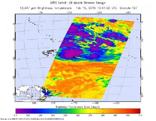
 On Feb. 16 the AIRS instrument aboard NASA's Aqua satellite saw cloud top temperatures in strong thunderstorms exceeding -63F/-53C (purple) around the center of circulation. Credit: Credits: NASA JPL, Ed Olsen
On Feb. 16 the Atmospheric Infrared Sounder (AIRS) instrument aboard Aqua saw cloud top temperatures exceeding -63 degrees Fahrenheit (-53 degrees Celsius) around the 23 nautical-mile wide eye. Storms with cloud tops that cold are very high into the troposphere and have the capability of producing heavy rainfall.
The Joint Typhoon Warning Center noted "Winston is currently positioned in a good environment for intensification with favorable sea surface temperatures and low vertical wind shear.
JTWC expects Winston to move northeast and start to re-strengthen. The storm is forecast to peak at 100 knots (115.1 mph/185.2 kph) by Feb. 17 and 18, south of American Samoa, before turning back west.
source: NASA/Goddard Space Flight Center