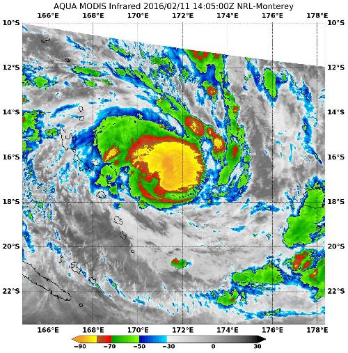
After Tropical Cyclone Winston formed between Vanuatu and Fiji in the Southern Pacific Ocean NASA's Aqua satellite passed overhead and saw powerful thunderstorms had quickly developed.
On Feb. 11 at 1405 UTC (9:06 a.m. EST), the MODIS instrument aboard NASA's Aqua satellite saw coldest cloud top temperatures near minus 80 degrees Fahrenheit/ minus 62.2 degrees Celsius indicating very powerful storms circling the center of Tropical Cyclone Winston. Those powerful storms are spiraling into the low-level center of circulation. Storms with cloud tops that cold and high in the troposphere have been shown to generate heavy rainfall.
Infrared data also showed that sea surface temperatures were near 31 degrees Celsius warm enough to keep fueling and strengthening the storm. Tropical cyclones need sea surface temperatures of at least 26.6 degrees Celsius (80 degrees Fahrenheit) to maintain intensity.
 On Feb. 11 at 1405 UTC (9:06 a.m. EST), the MODIS instrument aboard NASA's Aqua satellite saw coldest cloud top temperatures near -80F/- 62.2C and strongest storms circling the center of Tropical Cyclone Winston. Credit: Credit: Credits: NASA JPL, Ed Olsen
At 1500 UTC (10 a.m. EST), Winston's maximum sustained winds were near 55 knots (63.2 mph/101.9 kph). It was centered near 16.7 degrees south latitude and 171.6 degrees east longitude, about 398 nautical miles west of Suva, Fiji. Winston was moving to the south-southeast at 6 knots (6.9 mph/11.1 kph).
Winston is forecast to move south and continue between Vanuatu to the west and Fiji to the east while intensifying to 105 knots (120.8 mph/194.5 kph).
source: NASA/Goddard Space Flight Center