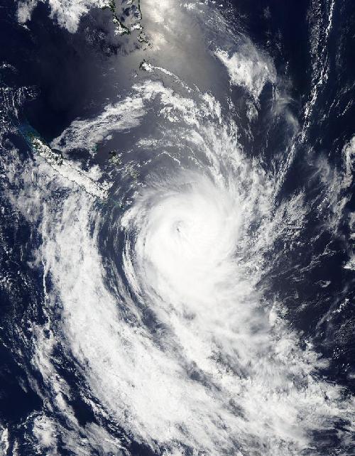
NASA satellite imagery showed that Tropical Cyclone Ula's eye appeared to be "closing" as clouds began filling it. Meanwhile New Caledonia remained on alert as the powerful storm continued moving away.
On Jan. 10 at 0900 UTC (4 a.m. EST) Tropical Cyclone Ula was a Category 4 Hurricane. Ula's maximum sustained winds at that time were near 115 knots (132.3 mph/213 kph). Since then, the storm has weakened.
Despite Ula weakening Mare and Ile des Pins, New Caledonia remained under a Yellow Alert for high ocean swells on Jan. 11.
 When NASA's Aqua satellite passed over Tropical Cyclone Ula on Jan. 11 at 0215 UTC (Jan. 10 at 9:15 p.m. EST) the powerful storm maintained an eye. Credit: Credits: NASA Goddard MODIS Rapid Response
When NASA's Aqua satellite passed over Tropical Cyclone Ula on Jan. 11 at 0215 UTC (Jan. 10 at 9:15 p.m. EST), the Moderate Resolution Imaging Spectroradiometer instrument known as MODIS took an image of the storm that revealed the eye had begun to fill with clouds. A band of powerful thunderstorms circled the eye but were more concentrated in the southern quadrant.
By 0900 UTC (4 a.m. EST) on Jan. 11, the Joint Typhoon Warning Center said that animated visible satellite imagery showed a deteriorating convective structure and the eye had become cloud-covered. A microwave satellite image showed the eye feature is weakening on the northern side, with all deep convection displaced to the southern side of the center.
Ula's maximum sustained winds were near 90 knots (103.6 mph/166.7 kph) and weakening. It is currently a Category 2 hurricane on the Saffir-Simpson Scale. It was centered near 24.6 degrees south latitude and 170.4 degrees east longitude. Ula was about 249 nautical miles southeast of Noumea, New Caledonia and moving to the south at 11 knots (12.6 mph/20.3 kph). By 2200 UTC (5 p.m. EST) Ula is forecast to make its closest approach to Kingston Island, where its center will be 254 nautical miles (292.3 miles/470.4 km) away.
Ula is moving into a very unfavorable environment with moderate to high vertical wind shear and cooler sea surface temperatures which will further weaken the storm. Ula is forecast to move north of New Zealand by January 12 when it is expected to be at tropical-storm strength.
source: NASA/Goddard Space Flight Center