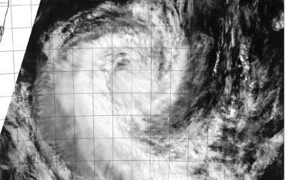
NASA's Terra satellite captured a visible image of Tropical Cyclone Guito as it exited the Mozambique Channel and moved into the open waters of the Southern Indian Ocean.
The Moderate Resolution Imaging Spectroradiometer or MODIS instrument that flies aboard NASA's Terra satellite captured a visible image of Tropical Cyclone Guito on Feb. 21 at 07:05 UTC/2:05 a.m. EST and took a visible image of the storm exiting the Mozambique Channel. The image showed bands of thunderstorms were still wrapping around the western quadrant of the storm.
At 0900 UTC/4 a.m. EST, Guito still had maximum sustained winds near 60 knots/69.0 mph/111.1 kph. It was located just south of the Mozambique Channel (the waterway between Mozambique and the island nation of Madagascar. Guito had moved into the open waters of the Southern Indian Ocean and was moving south at 12 knots/13.8 mph/22.2 kph.

NASA's Terra satellite passed over Tropical Cyclone Guito on Feb. 21 at 07:05 UTC and took this visible image of the storm exiting the Mozambique Channel.
(Photo Credit: NRL/NASA)
The Joint Typhoon Warning Center noted that animated multispectral satellite imagery also showed a tightly-wrapped, partially-exposed low-level circulation center. The strongest thunderstorms were located over the western and southern quadrants. Microwave satellite imagery showed an eye feature still existed.
Guito is expected to drift south and start to weaken on Feb. 22, becoming extra-tropical over the next several days.
Source: NASA/Goddard Space Flight Center