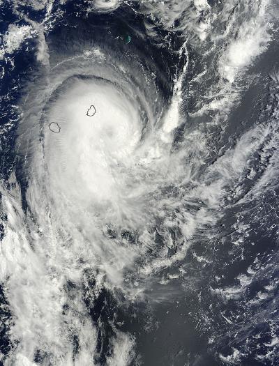
NASA's Terra satellite saw Tropical Cyclone Edilson pulling away from the island of Mauritius in the Southern Indian Ocean when it passed overhead on February 6, 2014.
The Moderate Resolution Imaging Spectroradiometer instrument aboard Terra took a visible image of Edilson as its northwestern quadrant still covered the island of Mauritius. Clouds from the fringe of Edilson also blanketed La Reunion Island (located to the southwest of Mauritius). The image showed a good rotation in the storm, with a shadowed center of circulation, hinting at the development of an eye. Microwave satellite data has also suggested the development of an eye. In addition, multi-spectral satellite imagery showed that the storm has been consolidating and there are strong curved bands of thunderstorms wrapping around the western quadrant of the storm.
Forecasters at the Joint Typhoon Warning Center expect Edilson to briefly become a hurricane over the next day.

On Feb. 6, 2014, at 06:10 UTC the MODIS instrument aboard NASA's Terra satellite captured this visible image of Tropical Cyclone Edilson over Réunion and Mauritius.
(Photo Credit: NASA Goddard MODIS Rapid Response Team)
At 1500 UTC/10 a.m. EST, Edilson's maximum sustained winds were near 55 knots/63.2 mph/101.9 kph. The tropical storm was centered near 23.3 south latitude and 57.5 east longitude, about 160 nautical miles/184.1 miles/296.3 km south-southeast of Port Louis, Mauritius. Edilson has been moving to the south-southwest at 16 knots/18.4 mph/29.6 kph.
Edilson is expected to track in a southerly direction over the next couple of days. It is forecast to move to the southwest before turning to the southeast sometime on February 9.
Source: NASA/Goddard Space Flight Center