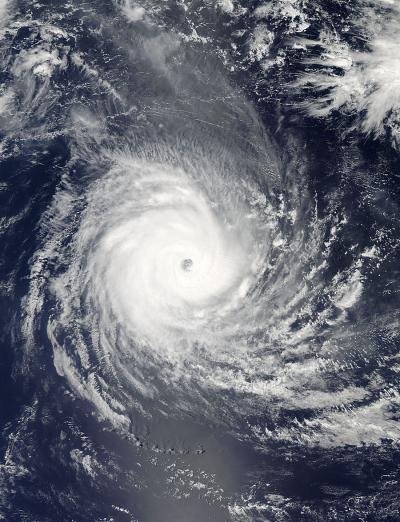
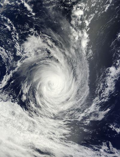
Tropical Cyclone Bruce's eye caught the eye of NASA's Aqua satellite when it passed overhead on December 21, but two days later, Bruce's eye appeared cloud-filled on satellite imagery.
On Dec. 21, Bruce still remained at hurricane strength as it continued moving through the Southern Indian Ocean. NASA's Aqua satellite passed over Tropical Cyclone Bruce on Dec. 21 at 0800 UTC/3:00 a.m. EST and saw its very distinct eye. On December 23 at 0500 UTC/12 a.m. EST when NASA's Terra satellite flew over Bruce, the MODIS instrument aboard captured a photograph that showed the eye had become cloud-filled. The Terra image also showed that Bruce had become elongated as a result of wind shear.

NASA's Aqua satellite passed over Tropical Cyclone Bruce in the Southern Indian Ocean on Dec. 21 at 0800 UTC/3:00 a.m. EST and saw its very distinct eye.
(Photo Credit: : NASA Goddard MODIS Rapid Response Team)
On December 23 at 1500 UTC/10 a.m. EST, Bruce's maximum sustained winds were near 80 knots/92.0 mph/148.2 kph, so it was still hurricane-strength, although weaker than it was over the two days previous. Bruce was centered near 24.5 south and 78.3 east, about 1,096 nautical miles south-southeast of Diego Garcia and moving to the south-southeast at 16 knots/18/4 mph/29.6 kph.
Bruce is expected to turn east over the next day. The Joint Typhoon Warning Center expects Bruce to weaken rapidly because of wind shear, movement into cooler waters, and becoming embedded in westerly winds.
Bruce is expected to start to turn extra-tropical later today, December 23, and by December 25 will be a remnant low pressure area.

NASA's Aqua satellite passed over Tropical Cyclone Bruce in the Southern Indian Ocean on Dec. 23 at 0500 UTC/12:00 a.m. EST and its eye had become cloud-filled.
(Photo Credit: : NASA Goddard MODIS Rapid Response Team)
Source: NASA/Goddard Space Flight Center