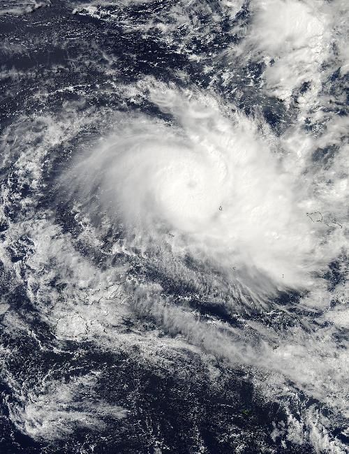
As the seven islands of American Samoa were bracing for Tropical Cyclone Amos, NASA's Aqua satellite saw the storm affecting the Southwestern Pacific Islands of Wallis and Futuna. Warnings were already in effect for American Samoa on April 22 as the storm continued moving east toward the islands.
A visible image of Amos was taken on April 22 at 0145 UTC (April 21 at 9:45 p.m. EDT) from the Moderate Resolution Imaging Spectroradiometer instrument aboard NASA's Aqua satellite. In the image, the southeastern fringe of strong thunderstorms circling the storm's center was near the island of Mata Utu, the capital of Wallis and Futuna, France. A large band of thunderstorms feeding into the center from the east is seen just west of American Samoa. American Samoa is a U.S. territory covering seven islands and atolls. The largest island, Tutuila, is the home of Pago Pago, the capital city.
On Friday, April 22 at 1500 UTC (11 a.m. EDT) Tropical Cyclone Amos' maximum sustained winds increased to 90 knots (103.6 mph/ 166.7 kph). The storm was moving to the east at 8 knots (9.2 mph/14.8 kph).
 On April 22 at 01:45 UTC NASA's Aqua satellite captured this image of Tropical Storm Amos affecting Wallis and Fortuna and headed east toward American Samoa. Credit: Credits: NASA Goddard MODIS Rapid Response Team
The 2:25 a.m. local time on Friday, April 22, the National Weather Service (NWS) in Pago Pago issued a high surf warning for all shores of American Samoa. NWS said that Hurricane Amos will generate dangerous surfs of 14 to 16 feet Friday afternoon along the southwest, west, northwest and north facing reefs, then building to near 18 to 22 feet Friday night into Saturday.
A high surf warning indicates dangerous large breaking waves will pound the shoreline in the warning area producing deadly rip currents and localized beach erosion. Also it is extremely dangerous to fish or observe waves from rocks during high surf conditions. Unwary beach walkers can be caught off guard as waves suddenly race farther up the beach than normal.
For updated forecasts from the NWS, Pago Pago, visit: http://www.weather.gov/ppg.
Forecasters at the Joint Typhoon Warning Center expect the storm to move east and intensify further to 115 knots (132.3 mph/213 kph), before a weakening trend begins as the storm turns to the south.
source: NASA/Goddard Space Flight Center