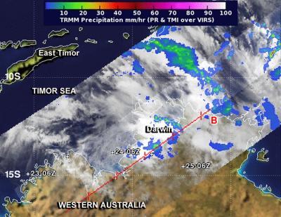
Tropical Cyclone made landfall near Darwin, Australia on November 24 as a weak tropical storm as NASA's TRMM satellite passed overhead and measured its rainfall.
The final warning on the tropical storm was issued on November 24 from the Joint Typhoon Warning Center at 0900 UTC/4 a.m. EST. At that time, Tropical Cyclone Alessia was located near 13.8 south latitude and 129.0 east longitude, about 136 nautical miles/156.5 miles/252 km southwest of Darwin, Australia. Alessia was moving to the east at 15 knots/17.2 mph/27.7 kph and had maximum sustained winds near 35 knots/40 mph/62 kph at the time.
NASA's Tropical Rainfall Measuring Mission or TRMM satellite passed over Tropical Storm Alessia on November 24 at 1325 UTC/8:25 a.m. EST and identified mostly light rain from the system with a small area of moderate rainfall, falling at a rate of 1.18 inch/30 mm per hour.

NASA's TRMM satellite passed over Tropical Storm Alessia on Nov. 24 at 1325 UTC/8:25 a.m. EST and identified mostly light rain from the system (blue) with a small area (green) of moderate rainfall.
(Photo Credit: Image : NASA/SSAI, Hal Pierce)
Cyclone Alessia crossed Australia's Northern Territory coast and made landfall south of Darwin during the night-time hours and quickly dissipated.
The Australian Bureau of Meteorology reported that the Upper Adelaide River, just north of where Alessia made landfall, received tropical-storm-force winds and received about 54 millimeters of rain. No damages were reported.
Source: NASA/Goddard Space Flight Center