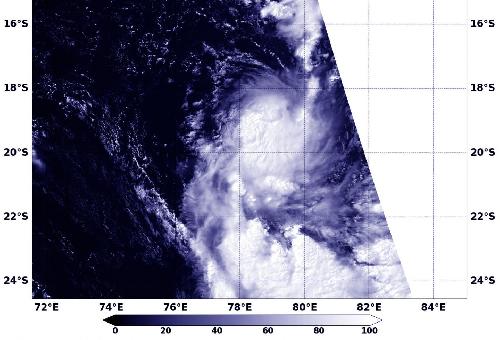
Tropical Cyclone 17S formed in the Southern Indian Ocean late on March 28. NASA's Terra satellite passed overhead.
The storm formed on March 28 around 2100 UTC (5 p.m. EDT) and strengthened into a tropical storm. At 0900 UTC (5 a.m. EDT), Tropical cyclone 17S's maximum sustained winds were near 40 knots (46 mph/74 kph). It was located near 17.8 degrees south latitude and 78.3 degrees east longitude, about 726 nautical miles south-southeast of Diego Garcia. It was moving to the south at 15 knots (17.2 mph/27.7 kph).
When NASA's Terra satellite passed over the storm the Moderate Resolution Imaging Spectroradiometer instrument aboard captured a visible image showing a slightly elongated storm with wind shear pushing clouds south of the well- defined low-level center.
 NASA's Terra satellite captured an image of the birth of Tropical Cyclone 17S in the Southern Indian Ocean on March 29. Credit: Credits: NASA/NRL
The Joint Typhoon Warning Center forecast calls for 17S to continue moving south and maintain current strength. After two days, adverse conditions are expected to lead to its demise as dry air approaches the system.
source: NASA/Goddard Space Flight Center