Satellite imagery indicated that Tropical Storm Tony is a small, compact storm, traveling through the central Atlantic Ocean.
On Oct 23, Tropical Depression 19 strengthened into Tropical Storm Tony in the central Atlantic Ocean. NOAA's GOES-13 satellite captured an image of Tony on Oct. 24 at 7:45 a.m. EDT that revealed that Tony is relatively small as it moves through the central Atlantic. Tropical storm force winds extend outward up to 70 miles (110 km) from the center. Tony is just over 140 miles in diameter as seen on the GOES-13 image. The GOES-13 satellite image was created by NASA's GOES Project at the NASA Goddard Space Flight Center, Greenbelt, Md.
Infrared satellite data from NASA's Aqua satellite shows that cloud top temperatures have cooled to -70 Celsius, indicating some very high, strong thunderstorms within.
At 5 a.m. EDT today, Oct. 24, Tony's maximum sustained winds are near 45 mph (75 kph). Some additional strengthening is expected today, followed by gradual weakening. The center of tropical storm Tony was located near about 1,415 miles (2,275 km) west-southwest of the Azores, near latitude 27.4 north and longitude 47.9 west. Tony is moving toward the east-northeast near 16 mph (26 kph) and the National Hurricane Center expects the storm to continue in that direction and speed up over the next two days.
Tony is also battling wind shear from the southwest and is headed into cooler waters. Both factors are expected to weaken Tony later in the week.
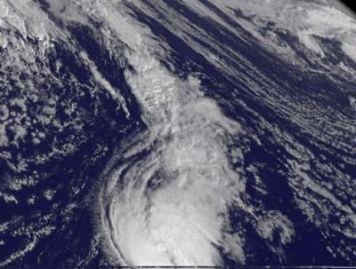
NOAA's GOES-13 satellite captured an image of Tony on Oct. 24 at 7:45 a.m. EDT that revealed that Tony is relatively small as it moves through the central Atlantic.
(Photo Credit: NASA GOES Project)
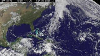
This animation of NOAA's GOES-13 satellite observations from Oct. 21-24, 2012, shows Tropical Storm Sandy become a hurricane just before making landfall in Jamaica and Tropical Storm Tony form and strengthen in the central Atlantic Ocean. Sandy became a hurricane on Oct. 24 at 11 a.m. EDT when its maximum sustained winds hit 80 mph (130 kph). At that time, it was centered about 65 miles (100 km) south of Kingston, Jamaica, near 17.1 North and 76.7 West. This visualization was created by the NASA GOES Project at NASA's Goddard Space Flight Center, Greenbelt, Md.
(Photo Credit: NASA GOES Project)
Source: NASA/Goddard Space Flight Center