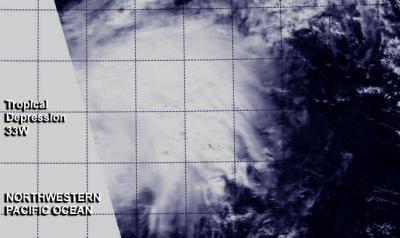
The Northwestern Pacific Ocean tropical cyclone season continues with the formation of the thirty-third tropical depression today, December 3, 2013.Two NASA satellites provided a look at the newly formed depression's cloud cover and rainfall rates.
At 0320 UTC today, NASA's Aqua satellite passed over the newborn depression. The Moderate Resolution Imaging Spectroradiometer or MODIS instrument captured a visible image of the storm, showing that the circulation had become more organized since the day before. The depression appeared as a rounded area of clouds on the MODIS image. NASA's Tropical Rainfall Measuring Mission or TRMM satellite also passed over the depression, but only over the northwestern edge. During the overpass, TRMM's Precipitation Radar instrument identified an area of moderate to heavy rainfall north of the center of circulation, where rain was falling at a rate of 1 inch/30 mm per hour.
On December 3 at 1500 UTC/10 a.m. EST, Tropical Depression 33W had maximum sustained winds near 30 knots/34.5 mph/55.5 kph. It was located approximately 369 nautical miles/424.6 miles/683.4 km west-northwest of Guam, near 16.0 north latitude and 138.9 east longitude. 33W was moving to the north at 6 knots/6.9 mph/11.1 kph but is expected to turn to the northeast.

At 0320 UTC on December 3/10:20 p.m. EDT, Dec. 2, NASA's Aqua satellite captured a visible image of the storm, showing that the circulation had become organized and appeared rounded.
(Photo Credit: Image : NRL-Monterey/NASA)
The National Weather Service does not expect Guam to be adversely affected by the depression as forecasts for the next several days call for mostly sunny skies. Wednesday, December 4 is expected to bring the breeziest conditions from the depression. The National Weather Service expects winds on that day to be from the east-southeast at 10 to 15 mph, with gusts as high as 18 mph.
Forecasters at the Joint Typhoon Warning Center expect Tropical Depression 33W to become extra-tropical in the next day or two. The depression is expected to curve to the northeast and continue in that general direction for the next couple of days toward the Northern Mariana Islands.
Source: NASA/Goddard Space Flight Center