Tropical Cyclone Bruce is winding down in the Southern Indian Ocean as wind shear and cooler waters affect the storm. NASA's Aqua satellite flew over Bruce on December 24 and showed that wind shear is having a strong effect on the system.
On December 24, Tropical Cyclone Bruce's maximum sustained winds were near 40 knots/46 mph/ 4.0 kph and weakening. Bruce was centered near 31.9 south and 84.9 east, about 1,594 nautical miles south-southeast of Diego Garcia. Bruce has sped up in its movement in a southeasterly direction and was moving at 26 knots/29.9 mph 8.1 kph.
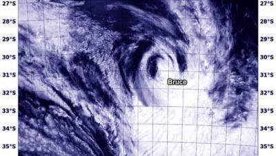
Satellite imagery showed that the low-level center is now exposed to outside winds and is quickly decaying. The Moderate Resolution Imaging Spectroradiometer or MODIS instrument aboard NASA's Aqua satellite captured a visible image of Tropical Cyclone Bruce on Dec. 24 at 08:25 UTC/3:25 a.m. EST. The MODIS image confirmed the strongest thunderstorms have been pushed southeast of the center from the northwesterly wind shear.

The MODIS instrument aboard NASA's Aqua satellite captured this visible image of Tropical Cyclone Bruce on Dec. 24 at 08:25 UTC/3:25 a.m. EST. Most of the precipitation was southeast of the center.
(Photo Credit: Image : NRL/NASA)
Bruce is also becoming embedded within the mid-latitude westerlies (winds) and is forecast to become extra-tropical low late on December 24, and later into a remnant low pressure area.
Source: NASA/Goddard Space Flight Center