Tropical low pressure area System 94S continues to soak Australia's Northern Territory near Darwin. NASA-NOAA's Suomi NPP satellite captured an image that showed the areas being affected by the developing low.
System 94S' center was located near 14.3 south and 131.3 east, about 115 nautical miles south-southeast of Darwin, Australia. According to the Joint Typhoon Warning Center or JTWC, maximum sustained surface winds are estimated at 20 to 25 knots/23.0 to 28.7 mph/37.0 to 46.3 kph.
Animated infrared satellite imagery shows that central convection is still strong and there are spiral bands of thunderstorms pushed west of the slowly developing low-level circulation center, which is over land. The thunderstorms are being pushed west by moderate to strong vertical wind shear.
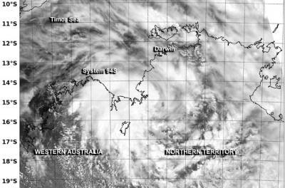
NASA-NOAA's Suomi NPP satellite passed over System 94S and the VIIRS instrument captured this visible image on Jan. 15 at 05:23 UTC/12:23 a.m. EST.
(Photo Credit: Image : NRL/NASA/NOAA)
It was on January 15 at 05:23 UTC/12:23 a.m. EST when NASA-NOAA's Suomi NPP satellite passed over System 94S and the VIIRS instrument or Visible Infrared Imager Radiometer Suite aboard captured a high-resolution visible image of the storm. The VIIRS image showed System 94S' cloud cover over both the Northern Territory and the northeastern part of Western Australia.
VIIRS, a scanning radiometer, collects visible and infrared imagery and radiometric measurements. VIIRS data is used to measure cloud and aerosol properties, ocean color, sea and land surface temperature, ice motion and temperature, fires, and Earth's albedo.
Source: NASA/Goddard Space Flight Center