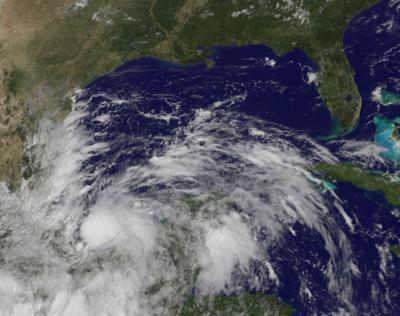
NASA and NOAA satellites have been tracking the progression of low pressure System 93L through the Caribbean Sea and into the southwestern Gulf of Mexico over a week's time, and it became Tropical Storm Ingrid mid-day on Sept. 13. NOAA's GOES-East satellite captured an image of Ingrid's center over the Bay of Campeche.
NOAA's GOES-East satellite sits in a fixed orbit and covers weather over the eastern U.S. and Atlantic Ocean, providing imagery continuously. NASA's GOES Project at NASA's Goddard Space Flight Center in Greenbelt, Md. created an image of Tropical Storm Ingrid at 1555 UTC/11:55 a.m. EDT, less than one hour after it was named. The image showed that clouds associated with Ingrid covered the Bay of Campeche, located in the southwestern Gulf of Mexico. Strong thunderstorms circled the center of the storm and the storm is expected to move slowly along the coast while its center stays over water over the next couple of days, bringing large amounts of rainfall to eastern Mexico.
System 93L strengthened into the tenth tropical depression of the Atlantic Ocean season and by 11 a.m. EDT, strengthened further to become the ninth tropical storm. Tropical Depression Eight was the only depression that did not achieve tropical storm status this year so far.

NOAA's GOES-East satellite captured this visible image of Tropical Storm Ingrid at 11:55 a.m. EDT on Sept. 13. Clouds associated with Ingrid covered the Bay of Campeche and strong thunderstorms circled the center of the storm.
(Photo Credit: Image : NASA GOES Project)
At 1500 UTC/11 a.m. EDT, Tropical Storm Ingrid was centered just 60 miles/95 km east-northeast of Veracruz, Mexico, and 175 miles/280 km southeast of Tuxpan, Mexico. That puts Ingrid's center near 19.4 north and 95.3 west. Ingrid had maximum sustained winds near 45 mph/75 kph and strengthening is possible over the next two days as Ingrid moves from a western track to a north-northwestern track. Ingrid's center is expected to move very close to the coast over the next couple of days. Tropical storm-force winds extend 35 miles/55 km from the center, making the compact storm just 70 miles/110 km in diameter.
A tropical storm warning is in effect for Coatzacoalcos to Cabo Rojo, and a tropical storm watch is in effect for north of Cabo Rojo to La Pesca.
Based on the National Hurricane Center's (NHC) expected track for Ingrid' over the next couple of days, eastern Mexico should prepare for a heavy soaking. The NHC noted that Ingrid is expected to produce 10 to 15 inches of rain over a large part of eastern Mexico with isolated amounts of 25 inches possible, especially in areas of mountainous terrain. These rains are likely to result in life-threatening flash floods and mudslides. Tropical-storm-force winds are expected within the warning area later in the day on Sept. 13.
Source: NASA/Goddard Space Flight Center