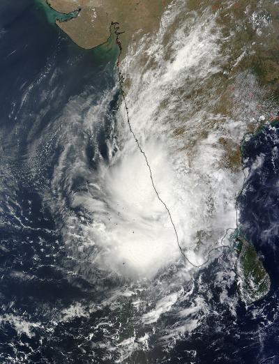
The tropical low pressure area known as System 91B has been making a slow northerly crawl while sitting inland in southwestern India, and NASA's Terra satellite captured a visible image of the struggling storm that showed half of it is over the Northern Indian Ocean.
NASA's Terra satellite passed over System 91B over southwestern India and the Moderate Resolution Imaging Spectroradiometer (MODIS) instrument captured a visible image on May 8 at 05:40 UTC/1:40 a.m. EDT. The despite having a poorly defined low-level circulation center on infrared imagery, the circulation is visible in the MODIS image. The MODIS image shows that the eastern quadrant of the broad tropical low pressure system remains over southwestern India, while the western quadrant extends into the Northern Indian Ocean. The thunderstorms are fragmented in the low pressure area.
The Joint Typhoon Warning Center (JTWC) estimates that the low-level center of System 91B is near 10.1 north latitude and 76.4 east longitude, just 20 nautical miles (23.0 miles/37.0 km) north-northeast of Cochin, India. The center of the storm has moved to the north over the last day and is about 15 nautical miles (17.2 miles/27.8 km) closer to Cochin than it was on May 7, indicating that it is a very slow moving system.

NASA's Terra satellite passed over System 91B over southwestern India and the MODIS instrument captured this visible image on May 8 at 05:40 UTC.
(Photo Credit: NASA Goddard MODIS Rapid Response Team)
On May 8, JTWC's website noted "upper-level analysis (of the atmosphere) indicates a marginal environment with moderate, easterly vertical wind shear offset by strong diffluence (upper air flowing off or away from the center of the storm).
Maximum sustained surface winds are estimated between 10 to 15 knots (11.5 to 17.2 mph/18.5 to 27.7 kph) as they were on May 7, so the winds have not weakened. Minimum sea level pressure is estimated to be near 1006 millibars.
As System 91B continues to linger over land, it continues to have a low chance for developing into a significant tropical cyclone within the next 24 hours.
Source: NASA/Goddard Space Flight Center