Tropical Storm Ula strengthened over the night-time hours of Jan. 6 to 7 and NOAA's GOES-West satellite and NASA's RapidScat instrument provided a look at the stubborn storm that is expected to continue to intensify and curve south.
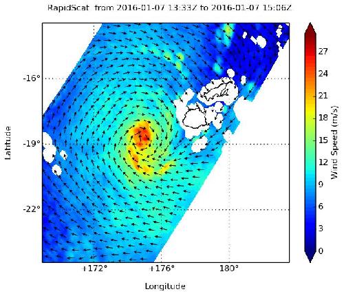
On Jan. 7 at 1400 UTC (9 a.m. EST) NASA's RapidScat instrument saw Tropical Storm Ula's strongest winds around the storm's center at 27 meters per second (60.4 mph/97.2 kph). By 2100 UTC (4 p.m. EST) on Jan. 7, sustained winds had increased from 35 to 55 knots (40 to 63.2 mph/62 to 101.9 kph) around the system and it maintained that strength on Jan. 8 at 0900 UTC (4 a.m. EST).
Ula was 240 nautical miles (276.2 miles/444.5 km) west of Suva, Fiji, near 18.4 degrees south latitude and 174.2 east longitude. That puts Tropical cyclone Ula about 366.6 miles (590 kilometers) east-northeast of Tafea province of Vanuatu. Tafea is the southernmost of the six provinces of Vanuatu. Ula was crawling to the west-northwest at 2 knots (2.3 mph/3.7 kph).
 On Jan. 7, RapidScat saw Tropical Storm Ula's strongest winds (red) around the center at 27 meters per second (60.4 mph/97.2 kph). Credit: NASA JPL, Doug Tyler Credit: Credits: NASA JPL, Doug Tyler
The Joint Typhoon Warning Center (JTWC) expects the system will peak at 65 knots on Jan. 9 and begin weakening by Jan. 11.
Forecasters at JTWC expect Ula to curve to the south, staying east of Noumea, New Caledonia on Jan. 10 and 11 and head toward northern New Zealand. Over the next several days, Ula is also expected to transition to an extra-tropical cyclone. For updated forecasts, visit the JTWC page: http://www.usno.navy.mil/JTWC/ . For forecasts from the Vanuatu Meteorological Services, visit: http://www.meteo.gov.vu/.
source: NASA/Goddard Space Flight Center