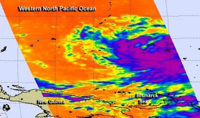
NASA's Aqua satellite passed over Tropical Storm Haiyan on Nov. 4 and infrared data showed a large area of powerful thunderstorms affecting Micronesia. The Joint Typhoon Warning Center has forecast newborn Tropical Storm Haiyan to strengthen to a powerful typhoon before making landfall in the Philippines on Nov 8.
In its orbit around the Earth, NASA's Aqua satellite passed over Tropical Storm Haiyan on Nov. 4 at 0347 UTC/10:47 p.m. EDT on Nov. 3. The Atmospheric Infrared Sounder or AIRS instrument captured infrared data that measured cloud top temperatures in the strengthening tropical storm. AIRS data showed a large area of strong convection with high, cold cloud tops. Temperatures exceeded -63F/-52C over a large area. Satellite data shows that the convection, the rising air that forms the thunderstorms that make up the tropical cyclone, have deepened, or strengthened over the previous 24 hours.
Microwave imagery from NASA's Tropical Rainfall Measuring Mission or TRMM satellite shows improved banding of thunderstorms wrapping around the tropical storm today, Nov. 5.
Haiyan is lashing the islands of Micronesia and warnings and watches are in effect today, Nov. 5.

NASA's Aqua satellite passed over Tropical Storm Haiyan on Nov. 4 at 0347 UTC/10:47 p.m. EDT on Nov. 3 as it was lashing the islands that make up Micronesia in the western North Pacific Ocean.
(Photo Credit: Image : NASA JPL, Ed Olsen)
Micronesia consists of a group of islands in the western Pacific Ocean that include the Marshall Islands, the Gilbert Islands including Kiribati, the Caroline Islands, Nauru, Wake Island and the Mariana Islands. The area contains thousands of small islands and is part of the larger Oceana.
A Typhoon Warning is in effect for Woleai in Yap State. A Typhoon Watch is in effect for Koror and Kayangel, Republic of Palau; for Satawal in Yap State; and for Faraulep, Fais, Ulithi, Yap Island and Ngulu in Yap State. A Tropical Storm Warning has been posted for Puluwat in Chuuk State as well as for Satawal in Yap State, and a tropical storm Watch is up for Ulul and Fananu in Chuuk State.
On Nov. 5 at 1500 UTC/10 a.m. EDT Haiyan's maximum sustained winds were near 45 knots/51.7 mph/83.3 kph and it is moving through an area of warm waters and low wind shear which is expected to help the storm strengthen. Haiyan was centered near 6.2 north and 147.6 east about 640 nautical miles east-southeast of Yap. Haiyan is moving to the west at 19 knots/21.8 mph/35.9 kph.
Haiyan is moving west-northwest through Micronesia. It is expected to pass between Yap and Palau on Nov. 6 before making landfall in the central Philippines. The Joint Typhoon Warning Center expects Haiyan to intensify to 120 knots/138.1 mph/222.2 kph as it approaches the central Philippines on Nov. 8. That strength is equal to a Category 4 hurricane on the Saffir-Simpson Scale.
Source: NASA/Goddard Space Flight Center