Southwesterly wind shear has taken its toll on hurricane Humberto, and NASA's TRMM satellite noticed that in rainfall data.
When NASA's Tropical Rainfall Measuring Mission or TRMM satellite passed over Hurricane Humberto on September 12, 2013 at 1625 UTC/12:25 p.m. EDT the eye was no longer visible. An analysis derived from
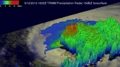
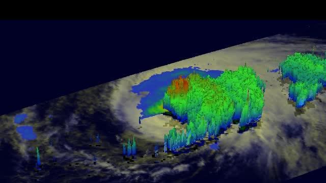
TRMM Microwave Imager (TMI) and Precipitation Radar (PR) data showed that most of the precipitation with Humberto was located in the northwestern quadrant, pushed there by the strong southwesterly wind shear.
TRMM found that the most intense rain was falling at a rate of over 99 mm/~3.9 inches per hour near Humberto's center. TRMM PR also found that the highest storm towers were reaching heights of about 13.7 km/8.5 miles in the same area.
At 5 a.m. EDT/0900 UTC on Sept. 13, Hurricane Humberto's maximum sustained winds were near 75 mph/120 kph, but the National Hurricane Center expects weakening over the next two days. Humberto is expected to drop to tropical storm status late on Sept. 13. The center of Hurricane Humberto was located near latitude 24.4 north and longitude 30.2 west, about 705 miles/1,135 km northwest of the Cape Verde Islands. Humberto is moving toward the north-northwest near 12 mph/19 kph and it is expected to turn toward the west-northwest.
Humberto is expected to weaken to a tropical storm late on Sept. 13, and continue moving through the open waters of the Central North Atlantic Ocean over the next several days.

The TRMM satellite passed over Hurricane Humberto on Sept. 12 at 12:25 p.m. EDT and most of the precipitation was pushed to the northwestern quadrant by the strong southwesterly wind shear.
(Photo Credit: Image : SSAI/NASA, Hal Pierce)

The TRMM satellite passed over Hurricane Humberto on Sept. 12 at 12:25 p.m. EDT and most of the precipitation was pushed to the northwestern quadrant by the strong southwesterly wind shear. The highest storm towers were reaching heights of about 13.7 km/8.5 miles in the same area.
(Photo Credit: Image : SSAI/NASA, Hal Pierce)
Source: NASA/Goddard Space Flight Center