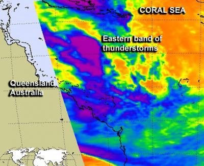
Infrared imagery from NASA's Aqua satellite revealed that a band of thunderstorms on the eastern side of Tropical Storm Oswald's remnants still contained some punch. Oswald's remnants have triggered severe weather warnings in parts of Queensland, Australia.
When NASA's Aqua satellite passed over the eastern side of the remnants of Tropical Cyclone Oswald the Atmospheric Infrared Sounder (AIRS) instrument captured an infrared image of a powerful band of thunderstorms over the Coral Sea. The band of thunderstorms east of Oswald's center showed some strong convection and cold cloud top temperatures as cold as -63 Fahrenheit (-52 Celsius). Those cold temperatures are indicative of high, powerful thunderstorms capable of dropping heavy rainfall.
Other satellite imagery indicated that Oswald's low-level circulation center had become well-defined, and bands of thunderstorms continued to wrap into it from the Coral Sea. The center of the low was over land and was out of the range of the satellite overpass, but also contained strong storms. Those storms are responsible for severe weather warnings issued on Jan. 24 by the Australian Bureau of Meteorology (ABM).
On Jan. 24 at 0600 UTC (1 a.m. EST/U.S/4 p.m. local time, Queensland.) the center of the remnant low pressure area was located near 19.7 south latitude and 146.8 east longitude, about 30 miles south of Townsville, Australia.

When NASA's Aqua satellite passed over the eastern side of the remnants of Tropical Cyclone Oswald the Atmospheric Infrared Sounder (AIRS) instrument captured an infrared image of a powerful band of thunderstorms over the Coral Sea. The band of thunderstorms east of Oswald's center showed some strong convection and cold cloud top temperatures as cold as -63 Fahrenheit (-52 Celsius). Those cold temperatures are indicative of high, powerful thunderstorms capable of dropping heavy rainfall.
(Photo Credit: NASA JPL, Ed Olsen)
At 1:15 a.m. local time (Queensland) on Friday, Jan. 25 (1515 UTC or 10:15 a.m. EST/U.S. Jan. 24), the ABM issued a severe weather warning that included destructive winds and heavy rainfall for Capricornia, Wide Bay and Burnett and parts of the Central Coast and Whitsundays, Central Highlands and Coalfields and Southeast Coast Forecast Districts.
ABM's bulletin noted that ex-Tropical Cyclone Oswald was located over land, approximately 93.2 miles (150 km) west-northwest of Mackay and moving south-southeast at about 12.4 mph (20 kph). ABM noted that strong winds gusting to 77.7 mph (125 kph) are possible about the Central Coast-Whitsundays and Capricornia districts, while wind gusts to 56 mph (90 kph) are possible over the Wide Bay and Burnett district, including areas between Agnes Water and Sandy Cape.
Oswald's remnants continue to generate heavy rainfall, and a warning for flash flooding is also in effect. At 1 a.m. local time (Queensland) on Friday, Jan. 25 (1500 UTC or 10 a.m. EST/U.S. Jan. 24), the Yeppoon area reported almost 8 inches (198 mm) of rain had fallen since the previous day, and severe flash flooding was occurring. For updated watches and warnings from ABM, visit: http://www.bom.gov.au/qld/warnings/
The Joint Typhoon Warning Center noted that Oswald has a medium chance for regaining tropical depression status over the next day.
Source: NASA/Goddard Space Flight Center