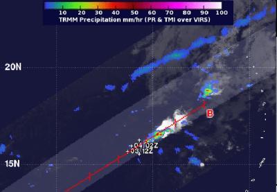
NASA's TRMM satellite noticed that rainfall became scarce in the Northwestern Pacific Ocean's thirty-third tropical depression in its second day of life. Tropical Depression 33W or TD 33W had weakened and TRMM showed only two isolated areas of heavy rainfall in the fragmented system.
At 0300 UTC on December 4/10 p.m. EST December 3, the Joint Typhoon Warning Center had already issued its final advisory on TD 33W. At that time, TD 33W's maximum sustained winds had already diminished to 25 knots/28.7 mph/46.3 kph. The center of the disorganized depression was located near 15.5 north and 139.1 east, about 354 nautical miles west-northwest of Andersen Air Force Base, Guam. It was moving to the southeast at 4 knots/4.6 mph/7.4 kph.
NASA's Tropical Rainfall Measuring Mission satellite known as TRMM measured the rainfall rates occurring within TD 33W on December 4 at 1045 UTC/5:45 a.m. EST. Two isolated areas within the circulation of the depression revealed heavy rainfall where rain was falling at 2 inches/50 mm per hour. The remaining rainfall in the system was scattered and light, but no rainfall around the center of circulation. Multispectral satellite imagery showed that the low-level circulation center was exposed to outside winds.

NASA's TRMM satellite captured this image of Tropical Depression 33W's sparse rainfall on Dec. 4 at 1045 UTC. There were two isolated areas of heavy (red) rainfall.
(Photo Credit: Image : NASA/SSAI, Hal Pierce)
Vertical wind shear has literally taken the wind out of the depression. Wind shear increased to more than 30 knots/34.5 mph/55.5 kph and was pounding the depression. TD 33W is expected to move to the northeast and dissipate over the next day.
Source: NASA/Goddard Space Flight Center