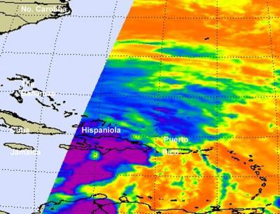
NASA's Aqua satellite passed over Hurricane Sandy as it was moving over eastern Cuba early on Oct. 25. The AIRS instrument captured an infrared image of Sandy that showed a large area of very high, cold cloud tops indicating the power within the storm. Sandy is now headed toward the Bahamas and warnings and watches have already been posted for the mainland U.S.
The Atmospheric Infrared Sounder (AIRS) instrument aboard NASA's Aqua satellite captured infrared imagery of Hurricane Sandy's eastern half on Oct. 25 at 0559 UTC (1:59 a.m. EDT) that showed some strong thunderstorms around the eye of Sandy. Those thunderstorms are reaching high into the troposphere where cloud top temperatures are as cold as -63 Fahrenheit (-52 Celsius). In previous studies, those areas where the temperatures were that cold indicated heavy rainfall.
By 11 a.m. EDT on Oct. 25, the eye was no longer apparent in satellite imagery or from aircraft observations. Forecasters at the National Hurricane Center noted that Sandy "has become somewhat disrupted on the western side by southwesterly flow from an upper-level low to the west."
Current Watches and Warnings
A Hurricane Warning is in effect for the Ragged Islands in the southeastern Bahamas, the Central Bahamas, the Northwestern Bahamas. A Tropical Storm Warning is in the effect for the Florida east coast from Ocean Reef to Flagler Beach, Lake Okeechobee, and the remainder of the southeastern Bahamas.
In addition, a Tropical Storm Watch is in effect for the Florida east coast from North of Flagler Beach to Fernandina Beach, Florida Upper Keys from Ocean Reef to Craig Key and Florida Bay.
Discontinued Watches and Warnings
As of 11 a.m. EDT several watches and warnings have been dropped as Sandy continues moving north. Cuba has discontinued the hurricane warning for the provinces of Camaguey, Las Tunas, Granma, Santiago de Cuba, Holguin, and Guantanamo. The tropical storm warning for Haiti has also been discontinued although heavy rains and gusty winds are expected to continue there today, Oct. 25.
Where is Sandy Now?
According to the National Hurricane Center, at 11 a.m. EDT on Thursday, Oct. 25, Hurricane Sandy's maximum sustained winds were near 105 mph (165 kph) with higher gusts. Sandy is a category two hurricane on the saffir- Simpson hurricane wind scale. Hurricane force winds extend outward up to 30 miles (45 km) from the center, while tropical-storm-force winds go up to 140 miles (220 km) from the center, making Sandy move than 280 miles in diameter. As a storm weakens, it tends to grow larger, so forecasters are closely watching Sandy.
Sandy is located near latitude 22.4 north and longitude 75.5 west. That's about 65 miles (110 km) south-southwest of Long Island, Bahamas and about 85 miles (135 km) south-southeast of Great Exuma Island. Sandy is moving toward the north near 16 mph (26 kph) and is expected to continue in that direction today, and turn north-northwest and slow down. The center of Sandy will move through the Central Bahamas later on Oct. 25 and through the northwestern Bahamas on Friday, Oct. 26. Sandy is expected to remain a hurricane as it moves through the Bahamas.

The AIRS instrument aboard NASA's Aqua satellite captured infrared imagery of Hurricane Sandy's eastern half on Oct. 25 at 0559 UTC (1:59 a.m. EDT) that showed some strong thunderstorms (purple) around the eye of Sandy. Those thunderstorms are reaching high into the troposphere where cloud top temperatures are as cold as -63 Fahrenheit (-52 Celsius). The yellow areas indicate the edges of the clouds associated with Sandy. Cloud cover extends far to the west, outside of Aqua's track.
(Photo Credit: NASA JPL, Ed Olsen)

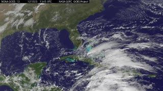
An animation of NOAA's GOES-13 satellite observations from Oct. 23-25, 2012, show Hurricane Sandy move over Jamaica and cross over eastern Cuba. At 8 a.m. EDT on Oct. 25, 2012, Hurricane Sandy had maximum sustained winds near 105 mph and was just 75 miles northeast of Holguin, Cuba.This visualization was created by the NASA GOES Project at NASA Goddard Space Flight Center, Greenbelt, Md., using observations from NOAA's GOES-13 satellite.
(Photo Credit: : NASA/NOAA GOES Project)
Source: NASA/Goddard Space Flight Center