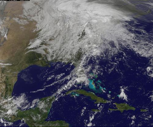
The remnant moisture from what was once Hurricane Patricia and moisture from the Gulf of Mexico were being transported north by a trough of low pressure over Wisconsin. The clouds and moisture were streaming into the Eastern third of the U.S. on October 28, 2015. The hybrid system was generating windy conditions which were seen from NASA's RapidScat instrument, while NOAA's GOES-East satellite captured an image of the impressive and sizeable cloud cover.
On Oct. 27, the RapidScat instrument aboard the International Space Station measured surface winds over the Gulf of Mexico and off the U.S. Atlantic coast. At 11 a.m. EDT strongest winds were along Florida's west coast near 18 meters per second/40.2 mph/ 64.8 kph. Stronger winds up to 27 meters per second/60.4 mph/97.2 kph were seen off the coast of the Carolinas. RapidScat measures wind speed at the surface which is always lower than speeds at higher altitude.
NOAA's GOES-East satellite captured an image of the clouds associated with the large system on October 28, 2015 at 1315 UTC (9:15 a.m. EDT). The low pressure center was located over southern Wisconsin, and the associated cold front draped from the low, south through the Tennessee Valley and over the Gulf of Mexico near the western Florida Panhandle. To the east of the cold front, was a warm front moving north through the Carolinas, bringing up more moisture and warm temperatures to the Mid-Atlantic.
 This visible image of the clouds associated with the low pressure area containing remnants of Hurricane Patricia over the US Mid-Atlantic and northeast was taken from NOAA's GOES-East satellite at 1445 UTC (10:45 a.m. EDT). Credit: Credits: NASA/NOAA GOES Project
On October 28, 2015, The National Weather Service's Weather Prediction Center (NPC) said that large upper-level trough (elongated area) of low pressure anchoring the Great Plains/Mississippi Valley region will continue to transport abundant moisture into the eastern third of the country. NPC said "This enhanced Gulf moisture combined with sufficient lift from embedded disturbances within the upper trough will support widespread rainfall over the northeastern United States. The WPC precipitation forecast indicates the heaviest amounts should be along the I-95 corridor stretching from the Upper Mid-Atlantic into New England. 2 to 3 inches of rainfall are possible through Friday morning across these regions."
On October 28, 2015, the National Weather Service's Weather Prediction Center expected widespread rainfall across much of the eastern third of the U.S. as the frontal system moves across the region. The heaviest rainfall will be across the Mid-Atlantic and New England, where 2 to 3 inches of rainfall is expected through early Friday, October 30. High winds are also possible from the Appalachians to New England."
The low pressure area is forecast to move into eastern Canada by October 30, and the associated cold front is expected to be off-shore in the Atlantic at that time, with another cold-front behind it, along the U.S. East coast. For updated forecasts, visit the NWS at http://www.weather.gov.
source: NASA/Goddard Space Flight Center