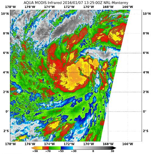
Infrared data from NASA's Aqua satellite showed powerful thunderstorms persisting in the center of a newly developed out-of-season tropical depression in the Central Pacific Ocean.
The first Tropical Depression of the 2016 hurricane season formed about five months early in the 2016 hurricane season, or two months late after the 2015 Central Pacific Hurricane Season ended. NOAA's Central Pacific Hurricane Center or CPHC considers the depression the first of the 2016 season since it formed in the 2016 calendar year.
The Moderate Resolution Imaging Spectroradiometer or MODIS instrument that flies aboard NASA's Aqua satellite captured infrared temperature data of the newly developed depression on Jan. 7 at 13:25 UTC (8:25 a.m. EST). The MODIS data showed cloud top temperatures of strong thunderstorms around the center of circulation as cold as -80 degrees Fahrenheit (-62.2 Celsius). Temperatures that cold indicate strong uplift in the storm and cloud tops high into the troposphere. NASA research has shown that storms with cloud tops that cold have the ability to generate heavy rain.
 On Jan. 7 at 13:25 UTC (8:25 a.m. EST) the MODIS instrument aboard NASA's Aqua satellite showed cloud top temperatures of strong thunderstorms around the center of circulation as cold as -80 degrees Fahrenheit (-62.2 Celsius). Credit: Credits: NASA/NRL
Forecaster Prichard of NOAA's CPHC noted in the Jan. 7 discussion "Thunderstorms associated with an area of low pressure in the far southwest corner of the central pacific hurricane area of responsibility have persisted sufficiently long to classify the system as a tropical cyclone."
Further, he noted "this low-latitude out-of-season system has tapped into significant directional (wind) shear of the low-level winds...with an El-Nino related westerly wind burst south of the
system...and prevailing easterly trade winds to the north providing the large scale conditions [and the spin] conducive for development."
On Jan. 7 at 10 a.m. EST (5 a.m. HST/1500 UTC) the center of Tropical Depression one-C (TD1C) was located near latitude 4.0 north and longitude 171.4 west. That's about 885 miles (1,425 km) south of Johnston Island. The depression is moving toward the north near 5 mph (7 kph) and that general motion is expected to continue the next day. Maximum sustained winds are near 35 mph (55 kph) and it is expected to become a tropical depression later in the day. The estimated minimum central pressure is 1004 millibars.
For updated forecasts on Tropical Depression 1C, visit NOAA's CPHC: http://www.prh.noaa.gov/hnl/cphc/.
source: NASA/Goddard Space Flight Center