The tropical low pressure area known as System 92B finally dissipated on the east central coast of India on May 27 after six days of struggling to develop. System 92B developed in the Bay of Bengal, Northern Indian Ocean basin on May 21. NASA's TRMM, Aqua and Suomi NPP satellites captured data on the low throughout the ups and downs it experienced until wind shear finally took its toll on the system.
NASA and the Japan Aerospace Exploration Agency's Tropical Rainfall Measuring Mission (TRMM) satellite passed over System 92B on May 19 and 20 and captured data on System 92B's rainfall rates and cloud heights. At the time, TRMM showed that System 92B had some strong thunderstorms and was generating heavy rainfall. Some of the storms reached over 14km (about 8.7 miles) high.
On May 22 at 7:11 UTC/3:11 a.m. EDT, NASA's Aqua satellite passed over System 92B and the Atmospheric Infrared Sounder or AIRS instrument captured infrared data on the low pressure area's cloud tops. Satellite imagery showed that the low-level circulation center was large and poorly defined with flaring and fragmented deep (or strong) convection (rising air that forms thunderstorms). The data showed two areas where thunderstorms had high cloud tops and very cold temperatures near -63F/-52C. Later in the day, wind shear increased and deep convection became more scattered and flared and dissipated over the storm's western side.
The Visible Infrared Imaging Radiometer Suite (VIIRS) instrument that flies aboard NASA-NOAA's Suomi NPP satellite captured data on System 92B on May 24. That data showed the bulk of low pressure area's clouds and showers were still being pushed west of center from persistent easterly vertical wind shear.
On May 25, System 92B's chances begin to improve again as it continued heading north in the Bay of Bengal. It was centered near 18.3 north latitude and 86.3 east longitude, just 90 nautical miles southeast of Brahmapur, India. System 92B's maximum sustained winds were estimated as high as 25 knots (28.7 mph/46.3 kph), and minimum sea level pressure was near 1002 millibars.

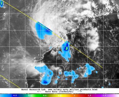
This combination TRMM and METEO-7 satellite image shows the remnants of System 92B over east central India. The dark blue indicates rainfall at a rate of 0.2 inches per hour.
(Photo Credit: Image : NRL/NASA/JAXA/ESA)
The Joint Typhoon Warning Center (JTWC) then upped the low pressure area's chances of becoming a tropical depression in the next 24 hours to medium despite its close proximity to the east coast of India.
On May 26 at 06:30 UTC/2:30 a.m. EDT, the JTWC noted System 92B was "no longer suspect for tropical cyclone formation."
At 07:30 UTC/3:30 a.m. EDT, the U.S. Naval Research Laboratory (NRL) issued a combination satellite image that showed the remnants of System 92B over Andhra Pradesh, India. Andhra Pradesh is one of India's 28 states, and is located on the southeastern coast facing the Bay of Bengal.
The NRL image combined rainfall rate data from NASA and JAXA's Tropical Rainfall Measuring Mission with visible imagery from the European Space Agency's METEO-7 satellite to provide a comprehensive look at the storm inside and out. The image showed the remnant clouds over Andhra Pradesh. Some areas within the state were experiencing rainfall at a rate of 0.2 inches per hour at that time.
The remnants of System 92B dissipated on May 27.
Source: NASA/Goddard Space Flight Center