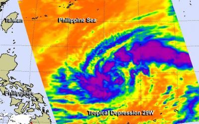
NASA infrared imagery revealed that bands of thunderstorms have been wrapping into the center of newborn Tropical Depression 29W, indicating it's organizing and strengthening in the Philippine Sea.
The Philippine Sea is located within the northwestern Pacific Ocean. It's located east and north of the Philippines and covers about 2 million square miles (5 million square kilometers).
The Atmospheric Infrared Sounder or AIRS instrument aboard NASA's Aqua satellite captured infrared data on Tropical Depression 29W on Oct. 29 at 04:23 UTC/12:23 a.m. EDT. AIRS data revealed strong thunderstorms with cloud top temperatures exceeding -63F/-52C that indicated they were high in the troposphere. They thunderstorms appeared in bands west and east of the center. Those thunderstorms were part of bands that formed around the circulation center.

The AIRS instrument aboard NASA's Aqua satellite captured infrared data on Tropical Depression 29W on Oct. 29 at 04:23 UTC/12:23 a.m. EDT and saw strong thunderstorms (purple) west and east of the center.
(Photo Credit: Image : NASA JPL, Ed Olsen)
On Oct. 29 at 11 a.m. EDT/1500 UTC, Tropical Depression 29W had maximum sustained winds near 30 knots/34.5 mph/55.5 kph. It was located near 15.7 north and 131.3 east, about 634 nautical miles/729.6 miles/1,174 km east of Manila, Philippines. 29W is moving to the west at 14 knots/16.1 mph/21.3 kph and is expected to continue moving in that general direction over the next couple of days.
Forecasters at the Joint Typhoon Warning Center noted that warm sea surface temperatures in the Philippine Sea (where it is currently moving through) will enable 29W to strengthen into a typhoon in the next one or two days.
29W is expected to move west crossing over Luzon (the northern Philippines) as a tropical storm sometime on Oct. 31 then move into the South China Sea.
Source: NASA/Goddard Space Flight Center