Hurricane Isaac made two landfalls in southeastern Louisiana. Isaac's first landfall occurred in southeastern Louisiana on Aug. 28 at 7:45 p.m. EDT (1145 UTC), second landfall on Aug. 29 at 6 a.m. EDT (1000 UTC). NASA's TRMM satellite observed heavy rainfall in this slow moving storm, which leads to higher rainfall totals and flooding.
NASA and NOAA satellites continue to provide detailed information to forecasters at the National Hurricane Center. Hurricane Isaac's first landfall occurred at 7:45 p.m. EDT in extreme southeastern Louisiana, bringing strong winds and dangerous storm surge along the northern Gulf coast. Landfall occurred in Plaquemines Parish, southwest of the mouth of the Mississippi River. Isaac was a category 1 storm upon landfall with maximum sustained winds of 80 mph (130 kmh).

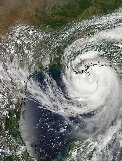
On Aug. 28, 2012 at 3:45 pm EDT, the MODIS instrument onboard NASA's Aqua satellite captured this image of Hurricane Isaac approaching southeastern Louisiana. It made landfall four hours later.
(Photo Credit: : NASA Goddard MODIS Rapid Response Team)
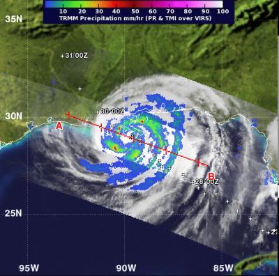
NASA's Tropical Rainfall Measuring Mission (TRMM) satellite captured a view of Isaac's rainfall rates on Aug. 28 at 11:05 p.m. EDT, just 3 hours and 20 minutes after its first landfall in southeastern Louisiana. The heaviest rainfall rates, near 50 mm (2.0 inches) per hour surrounded the center of the storm, causing inland flooding on its slow crawl.
At 6 a.m. EDT on Aug. 29, Isaac made a second landfall along the southern coast of Louisiana. At that time it was located near latitude 29.3 north and longitude 90.6 west, 35 miles south-southeast of Houma Louisiana, and moving west-northwest at 6 mph (9 kmh).
By 7 a.m. EDT, Isaac's maximum sustained winds were still hurricane strength, at 80 mph (130 kmh) as it continues to feed from the warm waters of the Gulf of Mexico. It was located about 20 miles (30 km) southeast of Houma, La. Near 29.4 north and 90.5 west. Isaac was moving to the northwest at 6 mph (9 kmh) with a minimum central pressure of 970 millibars.
A hurricane warning is in effect for east Of Morgan City, Louisiana to the Mississippi-Alabama border, including metropolitan New Orleans, Lake Pontchartrain and Lake Maurepas. A hurricane watch is in effect for Intracoastal city to Morgan City, Louisiana. A tropical storm warning is in effect for the Mississippi-Alabama Border to Destin, Florida, and from Morgan City to Sabine Pass, Texas. A tropical storm watch is in effect from east of High Island Texas to just west of Sabine Pass.
Flooding is a big threat from Isaac because of its slow movement, and because it is drawing a lot of energy from the warm waters of the Gulf of Mexico. Isolated tornadoes are also possible as Isaac continues moving inland.

NASA's TRMM satellite captured a view of Isaac's rainfall rates on Aug. 28 at 11:05 pm EDT, just three hours and 20 minutes after its first landfall in southeastern Louisiana. The purple areas indicated the heaviest rainfall rates, near 70 mm (2.7 inches) per hour.
(Photo Credit: : NASA/SSAI, Hal Pierce)

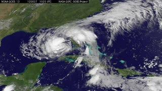
An animation of satellite observations from Aug. 27-29, 2012, shows Hurricane Isaac move through the Gulf of Mexico and make its first landfall in southeastern Louisiana on Aug. 28 at 7:45 pm EDT (1145 UTC), second landfall on Aug. 29 at 6 am EDT (1000 UTC). This visualization was created by the NASA GOES Project at NASA Goddard Space Flight Center, Greenbelt, Md., using observations from NOAA's GOES-13 satellite.
(Photo Credit: : NASA/NOAA GOES Project)
Source: NASA/Goddard Space Flight Center