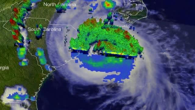
One of the TRMM Precipitation Radar's most useful functions has been it's ability to provide 3-D vertical profiles of precipitation from the surface up to a height of about 20 km (12 miles). TRMM PR data were used to create a 3-D view of hurricane Arthur and showed tall thunderstorm towers near the center of the hurricane. These "hot towers" found reaching heights of over 15.0 km (about 9.3 miles) are often a sign that a hurricane is becoming more powerful. Even taller thunderstorm tops were found reaching heights of 16km (about 9.9 miles) in the states of North and South Carolina.
A "hot tower" is a tall cumulonimbus cloud that reaches at least to the top of the troposphere, the lowest layer of the atmosphere. It extends approximately nine miles (14.5 km) high in the tropics. These towers are called "hot" because they rise to such altitude due to the large amount of latent heat. Water vapor releases this latent heat as it condenses into liquid. NASA research shows that a tropical cyclone with a hot tower in its eyewall was twice as likely to intensify within six or more hours, than a cyclone that lacked a hot tower.
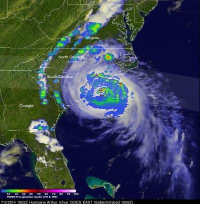
On July 4 at 7:00 a.m. EDT, Arthur was a category 2 hurricane with maximum sustained winds near 100 mph. A category 2 hurricane on the Saffir-Simpson hurricane scale has sustained winds between 96-110 mph. Satellite imagery showed that Arthur still maintained an eye, and that eye was centered near 36.5 north latitude and 74.7 west longitude. Arthur was moving to the northeast at a speedy 23 mph (37 kph) and is expected to speed up in the next couple of days. Arthur is expected to become a post-tropical cyclone tonight or Saturday, according to the National Hurricane Center (NHC).
The NHC forecast called for Arthur's center to move well offshore of the Mid-Atlantic coast of the U.S. today, pass southeast of New England tonight, and be near or over western Nova Scotia early on Saturday, July 5.
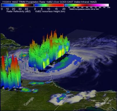
On July 3, NASA's TRMM satellite passed over Arthur and saw intense bands of thunderstorms north of Arthur's well defined eye dropping rainfall at a rate of over 98.4 mm (3.9 inches) per hour. Those areas had "hot tower" thunderstorms reaching 16km (about 9.9 miles) high.
(Photo Credit: Image : SSAI/NASA, Hal Pierce)
As a result of the forecast track, many warnings and watches are in effect from the Mid-Atlantic to Canada. A hurricane warning is in effect for Ocracoke Inlet, North Carolina to the North Carolina/Virginia border, and the eastern Albemarle Sound. A tropical storm warning is in effect for the North Carolina/Virginia Border to Cape Charles Light, Virginia including the mouth of the Chesapeake Bay, the western Albemarle Sound, Nantucket and Cape Cod, Massachusetts from Provincetown to Woods Hole.
Arthur is expected to pick up speed and zip up to the Canadian Maritimes late today, July 4, so tropical storm watches extend that far north. A tropical storm watch is in effect for New Brunswick from U.S./Canada border to Grand-Anse. It includes all of Nova Scotia Including Cape Breton Island, and all of Prince Edward Island.
NASA's TRMM satellite data was used to create this 3-D image of Hurricane Arthur on July 3 that showed "hot tower" thunderstorms reaching 16km (about 9.9 miles) high over North and South Carolina.
(Photo Credit: Image : SSAI/NASA, Hal Pierce)
On July 3, NASA's TRMM satellite passed over Arthur and saw intense bands of thunderstorms north of Arthur's well defined eye dropping rainfall at a rate of over 98.4 mm (3.9 inches) per hour.
(Photo Credit: Image : SSAI/NASA, Hal Pierce)
Source: NASA/Goddard Space Flight Center