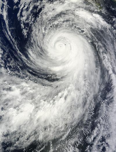
NASA's Terra satellite passed over Hurricane Marie when its eye was just to the west of Socorro Island in the Eastern Pacific. Marie's eye may have been near the island, but the storm extended several hundreds of miles from there.
On Aug. 25 at 18:20 UTC (2:20 p.m. EDT) the Moderate Resolution Imaging Spectroradiometer or MODIS instrument aboard NASA's Terra satellite captured Hurricane Marie's center just west of Socorro Island. The image showed Marie's tightly wound center and eye. A thick band of powerful thunderstorms surrounded the center of circulation, and bands of thunderstorms spiraled into the center from the west, that wrapped entirely around the outside perimeter. The image was created by the MODIS Rapid Response Team at NASA's Goddard Space Flight Center in Greenbelt, Maryland.
Mexico's Socorro Island is a small volcanic island located about 600 kilometers off the country's western coast. There are about 45 people on the island including the residents of a naval station. Socorro Island was pummeled with heavy rainfall, hurricane-force winds and high, dangerous surf.
Marie is also generating dangerous surf along the western coast of mainland Mexico. Swells generated by Marie are affecting much of the Baja California peninsula and the southern Gulf of California. The National Hurricane Center (NHC) noted that these swells are spreading northwestward and will reach the southern California later today. Life-threatening surf and rip current conditions are likely as a result of these swells...as well as minor coastal flooding.

On Aug. 25 at 18:20 UTC (2:20 p.m. EDT) the MODIS instrument aboard NASA's Terra satellite captured Hurricane Marie's center just west of Socorro Island, Mexico in the Eastern Pacific.
(Photo Credit: Image : NASA's Goddard MODIS Rapid Response Team)
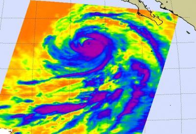
An infrared image of Hurricane Marie was captured on Aug. 26 at 5:35 a.m. EDT from the Atmospheric Infrared Sounder (AIRS) instrument aboard NASA's Aqua satellite. The AIRS image revealed very cold cloud top temperatures in powerful thunderstorms circling the eye of the storm. The National Hurricane Center noted that microwave data show that Marie continues to have a complicated inner core structure, with a remnant inner eyewall surrounded by a pair of larger concentric eyewall rings.
At 11 a.m. EDT (1500 UTC) today, August 26, Marie had been downgraded to a Category 2 hurricane on the Saffir-Simpson wind scale as maximum sustained winds dropped to 100 mph (155 kph). NHC expects Marie to continue weakening and to become a tropical storm by August 27. Marie was located near 20.7 north latitude and 119.0 west longitude, about 605 miles (970 km) west-southwest of the southern tip of Baja California. Marie is moving to the west-northwest near 15 mph (24 kph) and is expected to continue in that general direction.
The MODIS image confirmed that Marie is a large hurricane. Hurricane-force winds extend out 60 miles (95 km) from the center. The total diameter of the storm is about 600 miles as tropical-storm-force winds extend 275 miles (445 km) from the center.
For the latest updates (in Spanish) from the Mexican Weather Service, please visit: http://smn.cna.gob.mx/

This infrared image of Hurricane Marie on Aug. 26 at 5:35 a.m. EDT from the AIRS instrument aboard NASA's Aqua satellite shows its large expanse (over 600 miles) and powerful thunderstorms (purple).
(Photo Credit: Image : NASA JPL, Ed Olsen)
Source: NASA/Goddard Space Flight Center