Amara does, however, threaten Rodrigues Island. The Mauritius Meteorological Service or MMS has already put a cyclone class 2 warning in effect for Rodrigues Island. The island is part of the Republic of Mauritius and is located about 350 miles/560 kilometers east of Mauritius.
Amara was moving to the west-southwest at 9 knots and over the next several days is expected to take a more southern route. Occasional showers from Tropical Cyclone Amara are likely on Dec. 20 at night (local time) and will become more frequent, according to the MMS. MMS warns that sustained winds can be expected between 18.6 to 24.8 mph / 30 to 40 kph with gusts to 68.3 mph/75 kph. Amara is also expected to generate rough seas and ocean swells. Maximum significant wave heights can reach 9.1 meters/30 feet.
Amara was moving to the west-southwestward at 9 knots/10.3 mph/16.6 kph. The Joint Typhoon Warning Center expects Amara to continue moving slowly west-southwestward while it remains in a weak steering environment, moving between two deep layer subtropical ridges (elongated areas of high pressure).
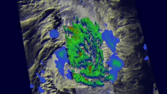
TRMM satellite on Dec. 16, at 2043 UTC showed scattered bands of moderate to heavy rain falling at a rate of over 76.9 mm/3 inches per hour spiraling into Amara's center. Cloud tops reached 13km/~8 miles high near the center and eastern side.
(Photo Credit: NASA/SSAI, Hal Pierce)
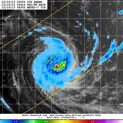
This image of Amara combines TRMM satellite rainfall data and clouds from Japan's METEO-7 satellite on Dec. 19. Heaviest rain was southeast of the center at 1.6 inches per hour.
(Photo Credit: NASA/JAXA/NRL)
Source: NASA/Goddard Space Flight Center