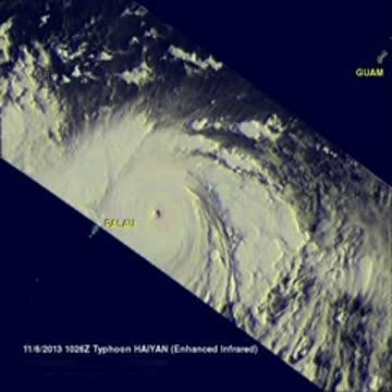
Satellite data also showed a persistent ring of deep convection around the small eye. Haiyan's eye appeared to be about 8 nautical miles in diameter. The TRMM satellite's microwave data showed an intense convective core (thunderstorms building around the eye) and improved convective banding of thunderstorms in all quadrants of the super-typhoon.
At 1500 UTC/10 a.m. EDT, Super Typhoon Haiyan had maximum sustained winds near 140 knots/161 mph/259 kph. That makes Haiyan equivalent to a Category 5 Hurricane on the Saffir-Simpson hurricane scale.
The U.S. National Hurricane Center website indicates that a Category 5 hurricane/typhoon would cause catastrophic damage: A high percentage of framed homes will be destroyed, with total roof failure and wall collapse. Fallen trees and power poles will isolate residential areas. Power outages will last for weeks to possibly months. Most of the area will be uninhabitable for weeks or months.
Hiayan's center was located near 8.1 north and 135.4 east, about 113 nautical miles/130 miles/209.3 km east-northeast of Koror, Palau. It is moving to the west at 18 knots/20.7 mph/33.4 kph and generating 43-foot/13.1-meter-high seas.
Super typhoon is expected to make landfall over the central Philippines just slightly on Nov. 8 and will slightly weaken as it tracks across the islands before emerging in the South China Sea.

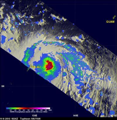
Data from TRMM's TMI and PR instruments on Nov. 6 at 1026 UTC revealed that rain was falling at a rate of over 100mm/~3.9 inches per hour (purple)around Haiyan's eye.
(Photo Credit: NASA/SSAI Hal Pierce)

Data from TRMM's TMI and PR instruments on Nov. 6 at 1026 UTC revealed that rain was falling at a rate of over 100mm/~3.9 inches per hour (purple) around Haiyan's eye.
(Photo Credit: NASA/SSAI Hal Pierce)
Source: NASA/Goddard Space Flight Center