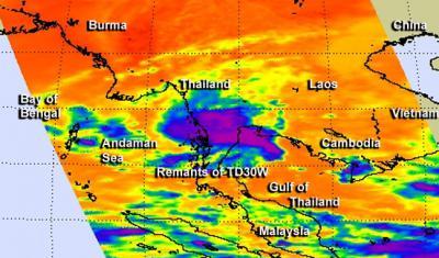
Now a remnant low pressure area, former Tropical Depression 30W may get new another life in another ocean. NASA's Aqua satellite captured an infrared image of the storm that showed strong circulation and persistent developing thunderstorms around its center.
Tropical Depression 30W moved through the Northwestern Pacific Ocean basin over the Philippines, past Vietnam and on Nov. 8, was entering the Andaman Sea, located in the eastern North Indian Ocean.
The Atmospheric Infrared Sounder or AIRS instrument that flies aboard NASA's Aqua satellite captured an infrared image of the remnants of Tropical Depression 30W on Nov. 8 at 06:41 UTC/1:41 a.m. EST as it was crossing southern Thailand. The remnant low pressure area still showed good mid-level circulation, although the lower-level circulation was still struggling as it moved over the Malay Peninsula. The AIRS data showed that convection (rising air that forms the thunderstorms that make up a tropical cyclone) was persisting around the center.

NASA's Aqua satellite captured an infrared image of the remnants of Tropical Depression 30W (purple) on Nov. 8 at 06:41 UTC/1:41 a.m. EST as it was crossing southern Thailand.
(Photo Credit: Image : NASA JPL, Ed Olsen)
Surface winds were as high as 20 knots/23.0 mph/37.0 kph, and the center was located near 12.5 north and 99.5 east, about 90 nautical miles southwest of Bangkok, Thailand.
Well, as expected, now entering the Andaman Sea, part of the Northern Indian Ocean, where sea surface temperatures are conducive for greater development. Forecasters at the Joint Typhoon Warning Center or JTWC are watching the storm for development as it may threaten India, Bangladesh and/or Myanmar (Burma). The JTWC gives the remnants a medium chance for redevelopment into a tropical depression over the weekend of Nov. 9 and 10.
Source: NASA/Goddard Space Flight Center