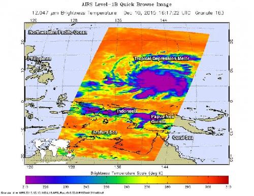
NASA's Aqua satellite captured an image as Tropical Depression Melor formed in the Northwestern Pacific Ocean close to the island of Yap.
The Atmospheric Infrared Sounder or AIRS instrument that flies aboard Aqua captured an infrared image as Tropical Depression Melor was consolidating on Dec. 10 at 1617 UTC (11:17 a.m. EST). AIRS infrared data showed a large concentration of powerful thunderstorms around the low-level center of circulation. Cloud top temperatures exceeded near minus 63 Fahrenheit (minus 53 Celsius), indicating strong atmospheric uplift. Thunderstorms with cloud top temperatures that cold and that high in the troposphere have been shown to produce heavy rainfall.
At 1500 UTC (10 a.m. EST) on Dec. 11, Tropical Depression Melor had maximum sustained winds near 30 knots (34.5 mph/55.5 kph). It was centered near 9.4 degrees north latitude and 136.7 degrees east longitude, or just 95.5 miles (153.7 km) west of Yap. It is also 776 miles (1,250 km) east of Maasin, Southern Leyte, Philippines. Melor was moving to the west-northwest at 15 knots (17.2 mph/27.7 kph).
 NASA's Aqua satellite captured this infrared image of Bohale on Dec. 10 at 2:47 p.m. EST that showed powerful thunderstorms with cold cloud top temperatures (purple) near minus 63 Fahrenheit (minus 53 Celsius) surrounded the center. Credit: Credits: NASA JPL/Ed Olsen
The storm will be identified in the Philippines as Tropical Storm Nonoy.
The Joint Typhoon Warning Center forecast calls for Melor to continue moving toward the west-northwest, and toward the Philippines. The system is expected to strengthen to 60 knots (69 mph/111 kph) before landfall in the eastern Philippines on Dec. 14.
source: NASA/Goddard Space Flight Center