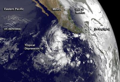
One week after the official start of hurricane season in the Eastern Pacific Ocean, the first tropical depression was born hundreds of miles southwest of Mexico. NASA's TRMM satellite and NOAA's GOES-West satellites provided looks inside and outside of the depression's clouds. Hurricane season in the Eastern Pacific began officially on May 15.
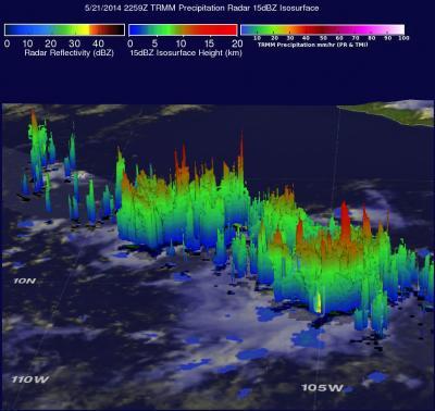
On May 21 at 22:59 UTC (6:59 p.m. EDT) the Tropical Rainfall Measuring Mission (TRMM) satellite passed over System 92E, which was what Tropical Depression 1E (TD1E) was called before it organized into a depression. TRMM's Precipitation Radar (PR) data were used to create a 3-D view of System 92E's rainfall structure and revealed a few strong thunderstorms reached altitudes of 16.5 km (about 10.2 miles). These tall thunderstorms are often a sign that a tropical cyclone is forming or strengthening. Within twenty-four hours

NOAA's GOES-West satellite captured this infrared image of Tropical Depression 1E on May 23 at 1200 UTC/8 a.m. EDT, less than 12 hours after its birth in the Eastern Pacific.
(Photo Credit: Image : NASA/NOAA GOES Project)
TD1E consolidated into a depression around 2 p.m. PDT (5 p.m. EDT) on May 22. At that time it was centered near 10.3 north latitude and 107.4 west longitude or about 635 miles (1,020 km) south-southwest of Manzanillo Mexico and had maximum sustained winds near 30 mph (45 kph).
Today, May 23, the depression continued to strengthen and maximum sustained winds increased to 35 mph (55 kph). The National Hurricane Center (NHC) expects the depression to become a tropical storm later today. At 0900 UTC (2 a.m. EDT) TD1E was located about 625 miles (1, 005 km) south-southwest of Manzanillo, Mexico near 10.8 north latitude and 108.2 west longitude. TD1E is moving to the west-northwest at 5 mph (7 kph) and has a minimum central pressure of 1006 millibars.
Forecaster Beven at NHC noted that "Convective banding is currently increasing near the center of Tropical Depression One-E over the northern semicircle. The depression is currently expected to be in an area of light/moderate southerly vertical wind shear during the forecast period. This should allow at least gradual strengthening."
The National Hurricane Center expects TD1E to move slowly toward the west-northwest or west is expected for the next couple of days.

TRMM's Precipitation Radar (PR) data were used to show a 3-D view of System 92E's rainfall structure on May 21. A few strong thunderstorms were found to reach altitudes of 16.5 km (about 10.2 miles). These tall thunderstorms are often a sign that a tropical cyclone is forming or strengthening.
(Photo Credit: Image : SSAI/NASA/Harold Pierce)
Source: NASA/Goddard Space Flight Center