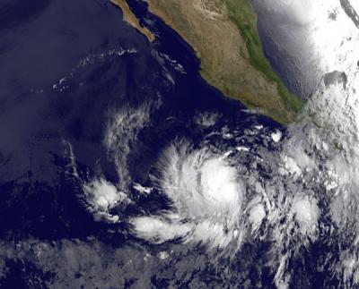
On May 21, NASA satellites were monitoring Tropical Depression 02E in the eastern Pacific Ocean, and 24 hours later it strengthened into the second tropical storm of the season. Tropical Storm Bud was captured by NOAA's GOES-13 satellite on May 22, and appears to be well-formed.
Tropical Storm Bud isn't going to stop there, however. According to the forecasters at the National Hurricane Center, Bud is expected to become a hurricane because of light to moderate wind shear and warm sea surface temperatures.
On May 22 at 0900 UTC (2 a.m. PDT/5 a.m. EDT), Tropical Storm Bud's maximum sustained winds were up to 40 mph (65 kph). Bud was centered about 515 miles (825 km) south of Zihuatenejo, Mexico, near 10.4 North and 103.0 West. Bud was moving to the west-northwest near 12 mph (19 kph).

This infrared image from NASA's GOES-13 satellite shows newly developed Tropical Storm Bud off the southwestern coast of Mexico in the eastern Pacific. The image was taken at 1200 UTC (8 a.m. EDT/5 a.m. PDT) and shows a well-developed tropical storm. Baja California is seen in the top center part of the image.
(Photo Credit: : NASA/NOAA GOES Project)
An infrared satellite image of Tropical Storm Bud was captured from the Atmospheric Infrared Sounder (AIRS) instrument onboard NASA's Aqua satellite on May 22, and showed a large area of very strong thunderstorms located mostly to the west of the center of circulation. The infrared image depicts that area with very cold cloud top temperatures that exceed -63 Fahrenheit (-52 Celsius). Microwave satellite imagery indicates that Bud's center of circulation is near the eastern edge of the large area of convection and thunderstorms. That's an indication of the moderate wind shear blowing from the east and pushing those thunderstorms west of the center.
Forecasters at the National Hurricane Center expect that Bud may become a hurricane by Wednesday, May 23 and begin curving to the northeast and toward the mainland of Mexico. Residents of western Mexico need to watch the progress of this tropical cyclone.
Source: NASA/Goddard Space Flight Center