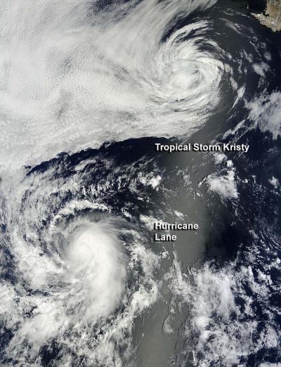
While Tropical Storm Kristy faded into a remnant low pressure area, Lane strengthened into a hurricane. NASA's Terra satellite caught a look at both storms when it passed overhead on Sept. 16 and showed a much tighter circulation within Hurricane Lane than in weakening Tropical Storm Kristy.
When NASA's Terra satellite passed over the Eastern Pacific on Sept. 16 at 18:45 UTC (2:45 p.m. EDT) the Moderate Resolution Imaging Spectroradiometer instrument aboard the satellite captured Tropical Storm Kristy (at the time a tropical storm) and Hurricane Lane, located to Kristy's southwest. Lane appeared to have a tighter circulation. Marine layer clouds were seen west of Tropical Storm Kristy in the image. The image was created by the NASA Goddard MODIS Rapid Response Team at NASA's Goddard Space Flight Center in Greenbelt, Md.
Kristy Becomes a Remnant Low Pressure Area
Kristy weakened to a remnant low pressure area on Monday, Sept. 17 by 11 a.m. EDT, about 645 miles (1,040 km) west-northwest of the southern tip of Baja California. It was centered near 26.2 North latitude and 119.5 west longitude and moving to the north-northwest at 6 mph (9 kmh). It is expected to turn north, northeast , then north-east northeast over the next two days. Kristy's maximum sustained winds were near 35 mph (55 kmh) and weakening.
The National Hurricane Center noted that swells generated by Kristy will continue to affect portions of southern and central Baja California on Sept. 17 and will gradually subside by Tuesday, Sept. 18. These swells could cause life-threatening surf and rip current conditions.
Lane Becomes a Hurricane
The twelfth tropical depression of the Eastern Pacific Ocean hurricane season was born on Sat. Sept 15 at 11 a.m. EDT about 1,080 miles 1,740 km west-southwest of the southern tip of Baja California.

When NASA's Terra satellite passed over the Eastern Pacific on Sept. 16 at 2:45 p.m. EDT the satellite captured Tropical Storm Kristy (at the time a tropical storm) and Hurricane Lane, located to Kristy's southwest. Lane appeared to have a tighter circulation. Marine layer clouds were seen west of Tropical Storm Kristy in the image.
(Photo Credit: NASA Goddard MODIS Rapid Response Team)
By Sept.17 at 11 a.m. EDT Lane had grown into a hurricane with maximum sustained winds near 75 kmh (120 kmh) and it was located about 1,160 miles (1,865 km) west-southwest of the southern tip of Baja California, near latitude 16.7 north and longitude 126.5 west. Lane is moving toward the north-northwest near 10 mph (17 kmh) and is expected to continue in that direction with a turn northwest on Sept. 18. The National Hurricane Center notes that some strengthening is possible over the next day.
Satellite data indicates that the sea surface temperatures in Lane's path are as cool as 24 Celsius (75.2 Fahrenheit), cooler than the 26.6C (80F) needed to maintain a tropical cyclone, so forecasters note that after a day, Lane should begin to weaken.
Source: NASA/Goddard Space Flight Center