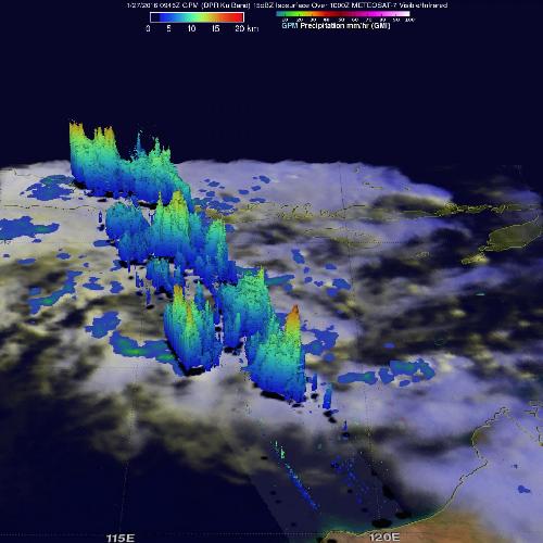
NASA's GPM satellite gathered rainfall rate and cloud height data on the newly developed tropical low pressure area designated System 92S in the Indian Ocean off Australia's northwestern coast. The low pressure area is expected to become a depression in the next day or two, according to the Australian Bureau of Meteorology.
The Global Precipitation Measurement Mission or GPM core observatory satellite flew over the area of disturbed weather on Jan. 27, 2016 at 0946 UTC (4:46 a.m. EST). GPM is managed by both NASA and the Japan Aerospace Exploration Agency.
GPM's Dual-frequency precipitation Radar (DPR) instrument measured rain falling at a rate of 96.7 mm (3.8 inches) per hour in towering convective storms within spiraling bands around the tropical low. GPM's Radar (DPR Ku band) made 3-D measurements of convective storm top heights and found some storm tops were found to reach altitudes of over 16 km (9.9 miles).
 On Jan. 28, 2016 , GPM measured rain falling at a rate of 96.7 mm (3.8 inches) per hour in towering convective storms within spiraling bands around System 92S, and storm heights reached over 16 km (9.9 miles). Credit: Credits: NASA/JAXA/SSAI, Hal Pierce
According to the Australian Bureau of Meteorology expect the storm to reach category 2 strength when it crosses the Pilbara coast Saturday morning, Jan. 30 (local Perth time). Area in the warning zone range from Bidyadanga to Mardie and the adjacent inland parts to Marble Bar and Pannawonica.
On Jan. 26, 2016 at 0617 UTC (1:17 a.m. EST), the Atmospheric Infrared Siunder or AIRS instrument aboard NASA's Aqua satellite saw strongest storms with coldest cloud top temperatures near -63F/-53C around and east of the center.
At 10:30 UTC (5:30 a.m. EST) on Jan. 28, 2016 the Joint Typhoon Warning Center said animated multispectral satellite imagery depicts rapidly improving spiral banding with central convection forming over a well-defined low level circulation center. A microwave image showed bands of strong thunderstorms wrapping around the southern and western quadrants of the storm.
At 11:00 p.m. AWST (10 a.m. EST) on Thursday, Jan. 28, 2016, the tropical low had sustained winds near the center of 55 kilometers per hour (34 mph). It was located near 17.0 degrees South latitude and 117.8 degrees East longitude, about 380 kilometers (236 miles) north northwest of Port Hedland and 425 kilometers (264 miles) north northeast of Karratha. System 92S was moving to the south at 12 kph (7.4 mph) .
The low is gradually strengthening and is forecast to become a tropical cyclone during Friday as it tracks south toward the Pilbara coast. It is forecast to reach category 2 intensity when it makes landfall on Saturday morning between Pardoo and Karratha, including near Port Hedland.
The Australian Bureau of Meteorology (ABM) has already issued alerts. A Yellow Alert is in effect for people in communities between Pardoo and Whim Creek including Port Hedland and South Hedland. A Blue Alert is in effect for the communities between Bidyadanga and Pardoo including Marble Bar, Sandfire and Pardoo; and between Whim Creek to Mardie including the communities of Point Samson, Wickham, Roebourne, Karratha, Dampier and Pannawonica.
ABM also warnred that the tides between Pardoo and Karratha are likely to rise above the normal high tide mark with very rough seas and possible flooding of low-lying coastal areas east of the crossing point. A Flood Watch is current for the Pilbara and a Flood Warning is current for the De Grey River Catchment.
For updated forecasts from the Australian Bureau of Meteorology, visit: http://www.bom.gov.au/.
source: NASA/Goddard Space Flight Center