Cyclone Victoria continued to intensify overnight from April 9 to April 10, and imagery from NASA's Aqua satellite showed a tighter storm circulation and a possible eye developing.
On April 10, 2013 at 0300 UTC, Victoria had maximum sustained winds near 60 knots (69 mph/111 kph). Victoria was located near 15.2 south and 103.8 east, about 735 nautical miles northwest of Learmonth, Australia. Victoria was moving to the south-southeast at 8 knots (9 mph/15 kph).
NASA's Aqua satellite passed over Tropical Cyclone Victoria on April 10 at 0705 UTC (3:05 a.m. EDT). The Moderate Resolution Imaging Spectroradiometer (MODIS) instrument aboard Aqua captured this visible image that showed a rounded Tropical Cyclone Victoria with strong thunderstorms around the center of circulation, moving through the Southern Indian Ocean.
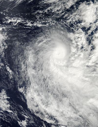
NASA's Aqua satellite passed over Tropical Cyclone Victoria on April 10 at 3:05 a.m. EDT. Victoria with strong thunderstorms around the center of circulation and appears to be developing an eye.
(Photo Credit: : NASA Goddard MODIS Rapid Response Team)
According to the Joint Typhoon Warning Center (JTWC), Victoria is in an area of low wind shear and warm waters. However, an approaching mid-latitude trough of low pressure will increase wind shear and as Victoria heads further south, the waters will cool.
Source: NASA/Goddard Space Flight Center