NASA's Aqua satellite passed over Cyclone Gino as the storm continues to wind up in the southern Indian Ocean, consolidating and strengthening. Infrared data shows the storm has strengthened but it is headed for cooler waters which will weaken it in coming days.
On Feb. 12 at 0841 UTC, NASA Atmospheric Infrared Sounder (AIRS) instrument that flies aboard the Aqua satellite captured infrared imagery of Cyclone Gino that showed the storm developed a large area of very cold, high cloud top temperatures around its center indicating powerful thunderstorms. Cloud top temperatures were as cold as -63 Fahrenheit (-52 Celsius) indicating strong storms that have the capability to produce heavy rainfall. The AIRS imagery also suggests a ragged eye had formed.
On Feb. 12 at 1500 UTC (10 a.m. EST), Cyclone Gino's maximum sustained winds had increased to 75 knots (86.3 mph/138.9 kph) making the storm a category one hurricane. Gino was centered near 17.1 south latitude and 79.5 east longitude, about 700 nautical miles (805.5 miles/1,296 km) southeast of Diego Garcia.
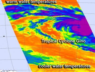
On Feb. 12 at 0841 UTC, NASA AIRS instrument infrared imagery showed that Cyclone Gino had developed a large area of very cold, high cloud top temperatures (purple) around its center indicating powerful thunderstorms.
(Photo Credit: NASA JPL, Ed Olsen)
Gino has been moving to the south-southwest at 10 knots (11.5 mph/18.5 kph), around the northwestern edge of a subtropical ridge (elongated area) of high pressure.
AIRS data shows that the sea surface temperatures around Gino are currently favorable for further development because they're around a warm 28 degrees Celsius (82.4 Fahrenheit). However, as Gino moves further south-southwest, those sea surface temperatures will drop, making it more difficult for the tropical cyclone to maintain intensity.
In addition, wind shear is expected to increase over the next three days as Gino moves further south. The Joint Typhoon Warning Center expects Gino to transition to a cold core low pressure area by Feb. 15.
Source: NASA/Goddard Space Flight Center